Upper Falls Covered Bridge (Weathersfield, Vermont)
USA /
Vermont /
Springfield /
Weathersfield, Vermont
World
/ USA
/ Vermont
/ Springfield
World / United States / Vermont
NRHP - National Register of Historic Places, covered bridge, historic landmark
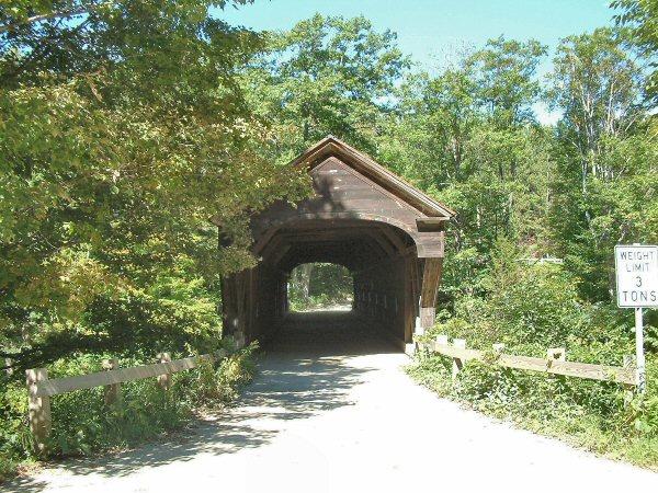


Built in 1840 or 1851; restored 1975-76. A single-span Town lattice truss 120' over the Black River. The bridges portals are rendered in the Greek Revival Mode with partial cornice returns and enclosed roof end overhangs bracket the splined gable-end boarding. The Sanderson Covered Bridge (Rutland county [WGN 45-11-02]) is the only other covered bridge in Vermont with cornice returns. It is Vermont's last example of splined boarding in a bridge portal. Also known as the Downers Covered Bridge.
Nearby cities:
Coordinates: 43°23'54"N 72°31'19"W
- Cornish-Windsor Covered Bridge 14 km
- Bath Covered Bridge 96 km
- Albany Covered Bridge 123 km
- Perrine's Bridge 216 km
- Wakefield Covered Bridge 368 km
- Pont Savoyard 446 km
- Hartland Covered Bridge 509 km
- Smolen-Gulf Bridge 696 km
- Harpersfield Covered Bridge - Harpersfield, Ohio 714 km
- Langley Covered Bridge 1075 km
- Weathersfield, Vermont 4.5 km
- Cavendish, Vermont 6 km
- Springfield, Vermont 13 km
- Reading, Vermont 13 km
- Chester, Vermont 15 km
- Charlestown 20 km
- Plymouth, Vermont 21 km
- Mount Holly, Vermont 23 km
- Shrewsbury, Vermont 30 km
- Mendon, Vermont 38 km