Hagley
United Kingdom /
England /
Hagley /
World
/ United Kingdom
/ England
/ Hagley
World / United Kingdom / England
village, parish
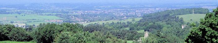
(Picture above) - Hagley, viewed from clent hills.
Hagley is a village and civil parish on the northern boundary of Worcestershire, England, near to the towns of Kidderminster and Stourbridge. The parish had a population of 4,283 in 2001,[1] but the whole village had a population of perhaps 5,600, including the part in Clent parish. It is in Bromsgrove District Council.
Hagley is a village and civil parish on the northern boundary of Worcestershire, England, near to the towns of Kidderminster and Stourbridge. The parish had a population of 4,283 in 2001,[1] but the whole village had a population of perhaps 5,600, including the part in Clent parish. It is in Bromsgrove District Council.
Wikipedia article: http://en.wikipedia.org/wiki/Hagley
Nearby cities:
Coordinates: 52°25'6"N 2°8'27"W
- Haybridge High School 0.8 km
- Hagley Park 2 km
- Clent Hills Country Park 2.7 km
- Churchill & Blakedown Golf Club 3.3 km
- Post Code Areas DY7, DY8 & DY9 4.1 km
- Bissell Wood 4.8 km
- Harvington 5.9 km
- Kinver CP 7.8 km
- Dudley (Metropolitan Borough of) 8.6 km
- South Staffordshire 21 km