Mughal Road at Mansir
India /
Jammu and Kashmir /
Thanamandi /
World
/ India
/ Jammu and Kashmir
/ Thanamandi
World / India / Jammu and Kashmir / Punch
road
Add category


It is said that the Pir Panjal range was named after a Faqir (Saint) by the same name located south of the himalayas at an average heigh of 5000m, these mountains strech from Gulmarg in the north-west to the southern rim of Kashmir valley. major passes in this range include the Pir panjal pass, dur to west of Srinagar, the Banihal pass which lies above Jhelum river at the southern end of Kashmir valley and the Simath pass linking kashmir with Kishtwar
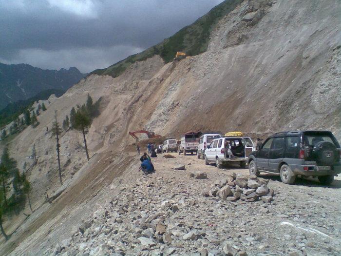
Mughal Road is the road between Bafliaz, a town in the Poonch district, to Shupiyan of Pulwama district in the Kashmir valley. The road is 84km long, and situated in the Jammu and Kashmir state of India. It passes over Pir Panjal Mountain range, at altitude of 11,500 ft (3505 m), that is higher than Banihal pass (2832 m).
The road brings the Poonch and Rajouri district closer to Srinagar in Kashmir valley. The distance between Srinagar and Poonch will be reduced from 588km to 126km. It makes for alternate road route to Kashmir valley from rest of India, other than over-crowded Jammu-Srinagar Highway through Banihal Tunnel(National Highway 1A). The road passes through Buffliaz, Poshana, Chattapani, Peer Ki Gali, Aliabad, Zaznar, Dubjan, Heerpora and Shopian.
The road was historically used by Moghul emperors to travel and conquer Kashmir during the sixteenth century. It was the route used by Akbar the Great to conquer Kashmir in 1586, and his son Emperor Jahangir died while returning from Kashmir on this road near Rajouri. Construction
The new road was proposed in the 1950s, with the intention of improving the economy of Poonch and Rajouri districts. Then Chief Minister Sheikh Abdullah had taken up this project in 1979 and named it "Mughal Road", but it came to halt as militancy took over. Bafliaz Bridge on the road was blown up by the militants. The construction of the prestigious project was started in 2005 with a target of completion in March 2007 and an estimated cost of INR 255 crores. The road cuts through Hirpora wildlife sanctuary. Initially, there was opposition to the construction of the road because it would fragment the wildlife and inhibit movement of animals, especially the endangered Markhor goat in the region. Also, opponents claimed the road will get early snowfall in winter and hence will not serve as an alternate route to existing Jammu-Srinagar highway. Finally Supreme Court gave conditional permission for the construction of the road. The construction work was completed on 4th December 2008,] it is proposed to be open to traffic by summer of 2010 for light vehicles. Double lane road will be completed by July 2011.
Nearby cities:
Coordinates: 33°38'19"N 74°30'38"E
- WASAK NAG ROAD KUND 57 km
- Jawahar (Banihal)Tunnel 65 km
- Shara e Resham/Silk Road 147 km
- BRIG (R) MUHAMMD RKRAM RODA 148 km
- Sohawra to Chakwal Road 156 km
- Francis Abad Sheikhupura Road ( By Amir David) 174 km
- Going up to Fotu La 214 km
- Baralacha La, 5045m 288 km
- Unpaved road to Batal, Kunjumla and Kaza 306 km
- End of motorable road 337 km
- BELA (the dhok) 2.7 km
- Tattakutti Peak,15502 Ft 7.2 km
- CHARAK COMPUTER 8.4 km
- Hirpora Wildlife Sanctuary 11 km
- mada village 13 km
- Bufliaz 15 km
- Poonch District 24 km
- Kulgam District 31 km
- Budgam District 32 km
- Rajauri District 43 km