Marikina Watershed (Rodriguez)
Philippines /
Southern Tagalog /
San Mateo /
Rodriguez
World
/ Philippines
/ Southern Tagalog
/ San Mateo
World / Philippines / Rizal / Rodriguez
forest, nature conservation park / area, invisible
Also referred to as: Marikina River Basin, and/or Marikina Watershed Reservation
Related article link: essc.org.ph/content/view/502/44/
*Marikina Watershed Forest Reserve
Location and Accessibility
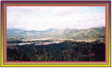
The Marikina Watershed is situated in the northeastern part of Rizal province, comprising five (5) municipalities and eight (8) relevant barangays. It lies 14°50’ to 14°34’ North Latitude and 121°20’ East Longitude, extending about 29 kms. from South to North and about 14 kms. from East to West. It comprises five municipalities of Rizal province such as Rodriguez, Antipolo, Baras, San Mateo and Tanay with an area of 18.966 hectares.
Climate
The climate belongs to type I, having dry and rainy season. The dry season lasts from November to April, and wet during the rest of the year.
Elevation and Topography
In the northeastern part is the Mt. Palagyo which is about 1,405 meters above sea level. In the northern part of the watershed is Mt. Kinawisan 1,016 meters. The slope is very steep and forms a V-shaped valley from the ridges line to the valley.
Valleys of Wawa and Montalban bounded the upper and lower reaches of the Marikina Watershed. The northern part is a steep and rugged mountain areas, while the southern part is a medium and high range of gentle hills.
Legal Basis
The Marikina Watershed Forest Reserve was classified as a watershed reserve under Executive Order No. 33 dated July 26, 1904. The initial area of the watershed is approximately 25,000 hectares.
On February 19, 1915, an additional area of 188 has. Was added to the original area and later, on February 24, 1915 Executive Order No. 16 excluded 2,195 has. from the watershed area. In 1919, an area of about 1,507 has. was transferred to the Metropolitan Watershed District (MWSS).
Presidential Decree No. 324 issued in 1973 excluded 1,729 has. in favor of Milestone Farm. Subsequently PD No. 2480 was issued in 1986 transferring 4,424 has. to MWSS as an additional relocation site.
Related article link: essc.org.ph/content/view/502/44/
*Marikina Watershed Forest Reserve
Location and Accessibility
The Marikina Watershed is situated in the northeastern part of Rizal province, comprising five (5) municipalities and eight (8) relevant barangays. It lies 14°50’ to 14°34’ North Latitude and 121°20’ East Longitude, extending about 29 kms. from South to North and about 14 kms. from East to West. It comprises five municipalities of Rizal province such as Rodriguez, Antipolo, Baras, San Mateo and Tanay with an area of 18.966 hectares.
Climate
The climate belongs to type I, having dry and rainy season. The dry season lasts from November to April, and wet during the rest of the year.
Elevation and Topography
In the northeastern part is the Mt. Palagyo which is about 1,405 meters above sea level. In the northern part of the watershed is Mt. Kinawisan 1,016 meters. The slope is very steep and forms a V-shaped valley from the ridges line to the valley.
Valleys of Wawa and Montalban bounded the upper and lower reaches of the Marikina Watershed. The northern part is a steep and rugged mountain areas, while the southern part is a medium and high range of gentle hills.
Legal Basis
The Marikina Watershed Forest Reserve was classified as a watershed reserve under Executive Order No. 33 dated July 26, 1904. The initial area of the watershed is approximately 25,000 hectares.
On February 19, 1915, an additional area of 188 has. Was added to the original area and later, on February 24, 1915 Executive Order No. 16 excluded 2,195 has. from the watershed area. In 1919, an area of about 1,507 has. was transferred to the Metropolitan Watershed District (MWSS).
Presidential Decree No. 324 issued in 1973 excluded 1,729 has. in favor of Milestone Farm. Subsequently PD No. 2480 was issued in 1986 transferring 4,424 has. to MWSS as an additional relocation site.
Wikipedia article: http://en.wikipedia.org/wiki/Upper_Marikina_River_Basin_Protected_Landscape
Nearby cities:
Coordinates: 14°42'3"N 121°12'36"E
- Tubbataha Reef Marine Park 652 km
- Malindang Mountain Range Natural Park 742 km
- Bunaken National Park 1482 km
- Dako Strict Nature Reserve 1501 km
- Tinombala Strict Nature Reserve 1551 km
- Bogani Nani Wartabone National Park 1570 km
- Kutai National Park 1632 km
- Aketajawe-Lolobata National Park 1661 km
- Aketajawe National Park 1699 km
- "Betung Kerihun" National Park 1764 km
- Mt. Lamita 2.1 km
- Mount Purro 2.4 km
- Mount Payacin 5.6 km
- Mount Ayaas 5.9 km
- Mount Domire 6.5 km
- Mount Caypipili 6.9 km
- Mt. Dacutan 8.3 km
- Mount Sumarapsap 8.9 km
- Rizal 15 km
- Bulacan 38 km