Lalitpur
India /
Uttar Pradesh /
Lalitpur /
World
/ India
/ Uttar Pradesh
/ Lalitpur
World / India / Uttar Pradesh / Lalitpur
city, taluka headquarter, district headquarter
Tehsil Lalitpur, District Lalitpur, Uttar Pradesh
Population of Lalitpur city is 133305 as per official census report for 2011.
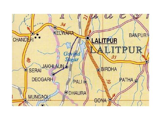
Lalitpur district is one of the districts of Uttar Pradesh. Lalitpur district is a part of Jhansi Division. Lalitpur is the main town and administrative headquarters. The district occupies an area of 5,039 km².
The district has a population of 977,447 (2001 census).
Lalitpur District is a part of Jhansi Division and was carved out as a district in the year 1974. Lalitpur is really not only the heartland but also a heart shaped district of Bundelkhand region. It is connected to Jhansi District of Uttar Pradesh by a narrow corridor to the northeast, otherwise almost surrounded by Madhya Pradesh state. Lalitpur district lies between latitude 24°11' and 25°14' (north) and longitude 78°10' and 79°0' (east) and is bounded by district Jhansi in the north, districts Sagar and Tikamgarh of Madhya Pradesh state in the east and Guna district of Madhya Pradesh separated by river Betwa in the west. The geographical area of the district is 5,039 sq. km with a population of 977,447 as per the census of year 2001. This district is well known for its culture, peace and natural beauty and have maximum dams in the state. Also has a number of historical and cultural places like Devgarh, Seeronji, Pavagiri, Devamata, Neelkantheshwar at Pali, Machkund ki Gufa.The territory of the present-day Lalitpur district was part of the state of Chanderi, founded in the 17th century by a Bundela Rajput who was descended from Rudra Pratap of Orchha. Chanderi, along with most of Bundelkhand, came under Maratha hegemony in the 18th century. Daulat Rao Sindhia of neighboring Gwalior annexed Chanderi state in 1811. In 1844, the former state of Chanderi was ceded to the British, and became the Chanderi District of British India, with Lalitpur town as the district headquarters. The British lost the district in the Indian Rebellion of 1857, and it was not reconquered until late 1858. In 1861, the portion of the district west of the Betwa, including Chanderi, was returned to Gwalior state, and the remainder was renamed Lalitpur district. It became a part of Jhansi district from 1891 to 1974. In 1974, the district was carved out from Jhansi district.
Lalitpur participated in the freedom struggle under the leadership of the two great bundelkhandi freedom fighters DEWAN SHATRUGHAN SINGH and his wife RANI RAJENDRA KUMARI.
DEWAN SHATRUGHAN SINGH and his wife RANI RAJENDRA KUMARI are two great Indian freedom fighters and Dewan Saheb was the father of the freedom movement in the whole of Bundelkhand, Dewan Shatrughan Singh is also known as 'Bundelkhand Gandhi' & 'Bundelkhand Kesri'. These were the two fountain heads of the freedom movement in all of Bundelkhand. They also were the main patrons of revolutionaries like Chandrashekhar Azad who frequented their Castle in their native village of Maungrauth. The Rani defeated the sitting UP Chief Minister C.B. Gupta as an independent candidate. They were also the main inspiration behind the Bhoodaan movement in Bundelkhand and Maungraut changed the history of the movement by becoming the first complete Gramdaan. Numerous scholars have done PhD's on the life of these 2 great Indian patriots. There is an annual mela on the birthday of these two stalwarts held annually in Maungrauth in 25 December and is attended by over 40,000 people. They opened numerous colleges and libraries in the Bundelkhand region and none were named after them. The district hospital of Hamirpur is named after Dewan Sahib after his death. Despite being from one of the most affluent families in Central India this couple sacrificed everything for the nation and donated their lands to the poor even prior to 1947. They were in British jails for the freedom struggle for over 9 years each. They are now the subject of folk tales and songs highlighting their bravery and hailing them as symbols of Bundelkhandi valorours.
Population of Lalitpur city is 133305 as per official census report for 2011.
Lalitpur district is one of the districts of Uttar Pradesh. Lalitpur district is a part of Jhansi Division. Lalitpur is the main town and administrative headquarters. The district occupies an area of 5,039 km².
The district has a population of 977,447 (2001 census).
Lalitpur District is a part of Jhansi Division and was carved out as a district in the year 1974. Lalitpur is really not only the heartland but also a heart shaped district of Bundelkhand region. It is connected to Jhansi District of Uttar Pradesh by a narrow corridor to the northeast, otherwise almost surrounded by Madhya Pradesh state. Lalitpur district lies between latitude 24°11' and 25°14' (north) and longitude 78°10' and 79°0' (east) and is bounded by district Jhansi in the north, districts Sagar and Tikamgarh of Madhya Pradesh state in the east and Guna district of Madhya Pradesh separated by river Betwa in the west. The geographical area of the district is 5,039 sq. km with a population of 977,447 as per the census of year 2001. This district is well known for its culture, peace and natural beauty and have maximum dams in the state. Also has a number of historical and cultural places like Devgarh, Seeronji, Pavagiri, Devamata, Neelkantheshwar at Pali, Machkund ki Gufa.The territory of the present-day Lalitpur district was part of the state of Chanderi, founded in the 17th century by a Bundela Rajput who was descended from Rudra Pratap of Orchha. Chanderi, along with most of Bundelkhand, came under Maratha hegemony in the 18th century. Daulat Rao Sindhia of neighboring Gwalior annexed Chanderi state in 1811. In 1844, the former state of Chanderi was ceded to the British, and became the Chanderi District of British India, with Lalitpur town as the district headquarters. The British lost the district in the Indian Rebellion of 1857, and it was not reconquered until late 1858. In 1861, the portion of the district west of the Betwa, including Chanderi, was returned to Gwalior state, and the remainder was renamed Lalitpur district. It became a part of Jhansi district from 1891 to 1974. In 1974, the district was carved out from Jhansi district.
Lalitpur participated in the freedom struggle under the leadership of the two great bundelkhandi freedom fighters DEWAN SHATRUGHAN SINGH and his wife RANI RAJENDRA KUMARI.
DEWAN SHATRUGHAN SINGH and his wife RANI RAJENDRA KUMARI are two great Indian freedom fighters and Dewan Saheb was the father of the freedom movement in the whole of Bundelkhand, Dewan Shatrughan Singh is also known as 'Bundelkhand Gandhi' & 'Bundelkhand Kesri'. These were the two fountain heads of the freedom movement in all of Bundelkhand. They also were the main patrons of revolutionaries like Chandrashekhar Azad who frequented their Castle in their native village of Maungrauth. The Rani defeated the sitting UP Chief Minister C.B. Gupta as an independent candidate. They were also the main inspiration behind the Bhoodaan movement in Bundelkhand and Maungraut changed the history of the movement by becoming the first complete Gramdaan. Numerous scholars have done PhD's on the life of these 2 great Indian patriots. There is an annual mela on the birthday of these two stalwarts held annually in Maungrauth in 25 December and is attended by over 40,000 people. They opened numerous colleges and libraries in the Bundelkhand region and none were named after them. The district hospital of Hamirpur is named after Dewan Sahib after his death. Despite being from one of the most affluent families in Central India this couple sacrificed everything for the nation and donated their lands to the poor even prior to 1947. They were in British jails for the freedom struggle for over 9 years each. They are now the subject of folk tales and songs highlighting their bravery and hailing them as symbols of Bundelkhandi valorours.
Wikipedia article: https://en.wikipedia.org/wiki/Lalitpur,_India
Nearby cities:
Coordinates: 24°41'30"N 78°24'41"E
- civil lines lalitpur 0.3 km
- Distt. Institute of Education & Training (D.I.E.T.) 0.7 km
- Sumera Talab 0.8 km
- vasundra colony 1.1 km
- OLD KUSHWAHA TALAB 2.2 km
- Lalitpur ByPass 2.4 km
- Galla Mandi 2.5 km
- Lalitpur Airstrip (Non-Operational) 2.9 km
- RSRMV..BSc,BCom College 2.9 km
- Electrical Substation 5.9 km