Shindand
Afghanistan /
Farah /
Sindand /
World
/ Afghanistan
/ Farah
/ Sindand
city
Add category
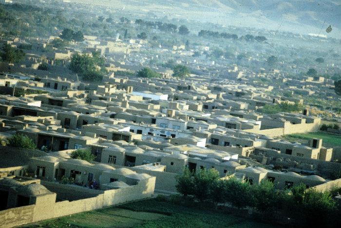
Shindand (Pashto: شين ډنډ; formerly known as Sabzavār - Persian: سبزوار) is a town and the center of the Shindand District, Herat Province, Afghanistan. It is located at 33°18′13″N 62°08′24″E / 33.3036°N 62.14°E / 33.3036; 62.14 at 1066 m Altitude. Near by the town is Shindand Airbase (a military and civil airport).
The town is bordered on the north by Shindand Airfield, currently occupied by Afghan, US and Italian forces of the Anti-Taliban ISAF coalition. The airfield is a former Soviet airfield, repaired by US Forces. The area is flat and arid, with foothills to the north and west. Cell phone towers, controlled by Iranians go off the air at 6 pm daily.[citation needed] The town is adjacent to Highway 1 (the Ring Road), the only paved highway in all of western Afghanistan. A free medical clinic supported by the Afghan Army provides free medical care for the population of the town.
The town is at the northern end of Zirko Valley, which is one of main centers of poppy production in Western Afghanistan as well as a confirmed Taliban government. Shindand is located south of Adriskan, where a large police training facility exists.
Wikipedia article: http://en.wikipedia.org/wiki/Shindand,_Herat
Nearby cities:
Coordinates: 33°17'58"N 62°9'21"E
- Birjand 282 km
- Mashhad 437 km
- Sabzevar 532 km
- Mazar-e-Sharif 589 km
- Bojnurd 646 km
- Ashgabat 653 km
- Türkmenabat 660 km
- Qarshi 703 km
- Navoiy 810 km
- Samarkand 826 km
- Nasrabad 0.6 km
- Pay Kushk 0.8 km
- Mahalleh-ye Tank-e Tel-e Shindand 1.6 km
- Khvajeh Nuh 1.7 km
- Robat-e Shinaana 1.9 km
- Mahalleh-ye Kondoz 2 km
- Qal`eh-ye `Omar 2.8 km
- Bagh-e Robat 3.4 km
- Ancient fortress 4.5 km
- Shindand Airbase 15 km