Cooch Behar
| city, taluka headquarter, district headquarter
India /
Bangla /
Koch Bihar /
World
/ India
/ Bangla
/ Koch Bihar
World / India / West Bengal / Kochbihar
city, taluka headquarter, district headquarter


Tehsil Cooch Behar Sadar, District Cooch Behar, Bengal, Bharat.
Coochbehar (Koch Bihar)
Cooch Behar (IPA: [kotʃbihaɹ]; Bengali: কোচবিহার, Kochbihar ) is the district headquarters and the largest town of Cooch Behar District in the Indian state of West Bengal.
It is situated in the foothills of the Eastern Himalayas and located at [show location on an interactive map] 26°22′N 89°29′E / 26.367°N 89.483°E / 26.367; 89.483.
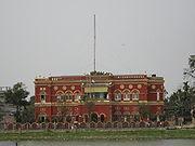
Cooch Behar is the only planned town in North Bengal region with remnants of royal heritage.[1] One of the main tourist destinations in West Bengal, the town is well-known for the Cooch Behar Palace and Madan Mohan Bari and has been declared a heritage town.
Cooch Behar/Koch Behar the land of Koch Rajbongshis. Cooch Behar (Bengali : কোচবিহার, Rajbongshi/Kamatapuri : কোচবিহার) is a district of the state of West Bengal, India, as well as the name of the town which gives its name to the district. During the British Raj, the town of Cooch Behar was the seat of a princely state of the same name, ruled by the Narayan dynasty. In course of time, Cooch Behar has been transformed from a kingdom to a state and from a state to the present status of a district. Before 28 August 1949, Cooch Behar was a Princely state ruled by the king of Cooch Behar, who had been a feudatory ruler under British Government. By an agreement dated 28th August, 1949 the king of Cooch Behar ceded full and extensive authority, jurisdiction and power of the state to the Dominion Government of India. The transfer of administration of the state to the Govt. of India came into force on 12 September 1949. Eventually, Cooch Behar was transferred and merged with the province of West Bengal on 19 January 1950 and from that date Cooch Behar emerged as a new District in the administrative map of West Bengal. The name "Cooch-Behar" is derived from the name of the KochRajbongshi tribe that is indigenous to this area. The word "Behar" is the Sanskrit word "bihar" (to travel) which means the land through which the "KochRajbongshi" Kings used to travel or roam about ("bihar"). The great KochRajbongshi King that has ever ruled in the Kingdom of Kamatapur is Maharaj Naranarayan, as well as his younger brother Prince Chilaray and other descendents. The Historical Kamatapur Comprises the total North Bengal maximum parts of Assam, some parts of present Bangladesh and a few parts of Bhutan. Visit the Indian Gov. Official URL to Know more about Kamata Kingdom. Ref: www.coochbehar.nic.in
Coochbehar (Koch Bihar)
Cooch Behar (IPA: [kotʃbihaɹ]; Bengali: কোচবিহার, Kochbihar ) is the district headquarters and the largest town of Cooch Behar District in the Indian state of West Bengal.
It is situated in the foothills of the Eastern Himalayas and located at [show location on an interactive map] 26°22′N 89°29′E / 26.367°N 89.483°E / 26.367; 89.483.
Cooch Behar is the only planned town in North Bengal region with remnants of royal heritage.[1] One of the main tourist destinations in West Bengal, the town is well-known for the Cooch Behar Palace and Madan Mohan Bari and has been declared a heritage town.
Cooch Behar/Koch Behar the land of Koch Rajbongshis. Cooch Behar (Bengali : কোচবিহার, Rajbongshi/Kamatapuri : কোচবিহার) is a district of the state of West Bengal, India, as well as the name of the town which gives its name to the district. During the British Raj, the town of Cooch Behar was the seat of a princely state of the same name, ruled by the Narayan dynasty. In course of time, Cooch Behar has been transformed from a kingdom to a state and from a state to the present status of a district. Before 28 August 1949, Cooch Behar was a Princely state ruled by the king of Cooch Behar, who had been a feudatory ruler under British Government. By an agreement dated 28th August, 1949 the king of Cooch Behar ceded full and extensive authority, jurisdiction and power of the state to the Dominion Government of India. The transfer of administration of the state to the Govt. of India came into force on 12 September 1949. Eventually, Cooch Behar was transferred and merged with the province of West Bengal on 19 January 1950 and from that date Cooch Behar emerged as a new District in the administrative map of West Bengal. The name "Cooch-Behar" is derived from the name of the KochRajbongshi tribe that is indigenous to this area. The word "Behar" is the Sanskrit word "bihar" (to travel) which means the land through which the "KochRajbongshi" Kings used to travel or roam about ("bihar"). The great KochRajbongshi King that has ever ruled in the Kingdom of Kamatapur is Maharaj Naranarayan, as well as his younger brother Prince Chilaray and other descendents. The Historical Kamatapur Comprises the total North Bengal maximum parts of Assam, some parts of present Bangladesh and a few parts of Bhutan. Visit the Indian Gov. Official URL to Know more about Kamata Kingdom. Ref: www.coochbehar.nic.in
Wikipedia article: http://en.wikipedia.org/wiki/Cooch_Behar
Nearby cities:
Coordinates: 26°18'58"N 89°27'36"E
- Siliguri 127 km
- Khulna 376 km
- Durgapur 377 km
- Dhanbad 415 km
- Kolkata 428 km
- Bokaro Steel City 452 km
- Patna 452 km
- Kharagpur 493 km
- Jamshedpur 517 km
- Ranchi 533 km
- Indrajit Colony 0.5 km
- Cooch Behar Panchanan Barma University Campus 0.7 km
- Nilkuthi Rail ghumty 0.9 km
- COOCHBEHAR ARMYCAMP (BY APU) 1 km
- Coochbehar Park 1.4 km
- NILKUTHI,BABURHAT, COOCHBEHAR 1.5 km
- Runway 1.7 km
- Chakchaka Colony 1.8 km
- Cooch Behar Airport. 1.8 km
- New Cooch Behar 3.5 km
Comments