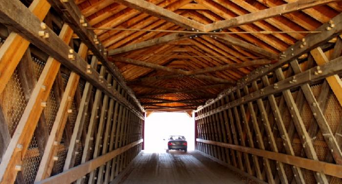
Eagleville Covered Wooden Bridge
USA /
New York /
Cambridge /
World
/ USA
/ New York
/ Cambridge
World / United States / New York
bridge, covered bridge


www.coveredbridgesite.com/ny/eagleville.html
maps.live.com/default.aspx?v=2&cp=43.083477~-73.313551&...
Town: Salem
Locality: Eagleville
Position - Lat:
Lon: N 43º 04.994'
W 73º 18.809'
Bridge Carries: Eagleville Road
Bridge Crosses: Battenkill River
Bridge Traffic: Vehicular
Truss Type: Town Lattice Truss
Year Built: 1858
Builder: Ephraim W. Clapp
Structure Characteristics: Length: 101'-0"
Width: 17'-3"
World Guide No.: 32-58-01
National Register of Historic Places Date:
March 8, 1978
Nearby cities:
Coordinates: 43°4'59"N 73°18'49"W
- Batchellerville Bridge 65 km
- Champlain Bridge 106 km
- Bridges of Keeseville 159 km
- Old Railroad bed 169 km
- Railway bridge 210 km
- Missisquoi Bay Bridge 211 km
- Rouses Point Bridge 213 km
- Seaway International Bridge / Three Nations Crossing (Border crossing) 243 km
- Old Railroad beds 245 km
- Ogdensburg-Prescott International Bridge 253 km
- Salem, New York 7.5 km
- Town of Greenwich, New York 16 km
- Easton, New York 20 km
- Argyle, New York 21 km
- Rupert, Vermont 22 km
- Manchester, Vermont 22 km
- Hebron, New York 23 km
- Dorset, Vermont 29 km
- Hartford, New York 32 km
- Pawlet, Vermont 32 km