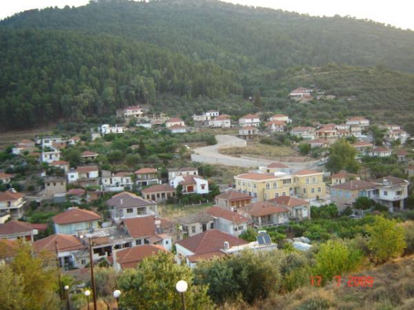
Paravola
Greece /
Aitolia kai Akarnania /
Paravyla /
World
/ Greece
/ Aitolia kai Akarnania
/ Paravyla
, 2 km from center (Παραβόλα)
World / Greece / Dytiki Ellada
region, invisible, draw only border, department - administrative division


Kapodistrian municipality designated in recent years and includes the administration of the settlements around the region as a whole.
In the past , for some time, was the administrative community of Thestieon, later became the local capacity again.
Culture, in the center axis of the towering hill, by name Paliokastro, save where the ruins of the ancient town Aitoliki Voukatio the fortress.
Geographically situated on the north shore of Lake Trichonida.
page:www.wiw.gr/english/paravola_municipality_of_paravola/
Nearby cities:
Coordinates: 38°36'9"N 21°31'20"E
- Peripheral unit of Achaea 33 km
- Peripheral unit of Phocis 36 km
- Peripheral unit of Ilia 66 km
- Peripheral unit of Karditsa 107 km
- Peripheral unit of Arta 123 km
- Peripheral unit of Messenia 124 km
- Peripheral unit of Trikala 149 km
- Peripheral unit of Larissa 180 km
- Peripheral unit of Thesprotia 188 km
- Peripheral unit of Ioannina 223 km
- forest Paravola 2.3 km
- Peristeri 5.4 km
- Lake Trichonida 5.8 km
- Koka 8.6 km
- Aghrinio Municipality 8.9 km
- Agrinion 12 km
- Thermo Municipality 16 km
- Peripheral unit of Aetolia-Acarnania 19 km
- Nafpaktia Municipality 23 km
- Peripheral unit of Evrytania 42 km