Ubehebe Crater
USA /
California /
Keeler /
World
/ USA
/ California
/ Keeler
World / United States / California
fault (geology), basalt, maar (crater)
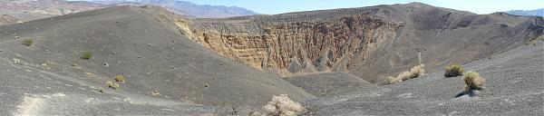


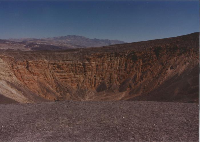
Ubehebe Crater is the largest of several maar craters in the immediate area.
A small quantity of basaltic magma encountered underground water producing a series of phreatic eruptions that are recorded in the black layers of pyroclastic ejecta seen across the crater from the parking lot. The next largest crater is "Little Hebe," a short, steep walk up to the south. Ubehebe itself is about ½ mile across, 500 feet deep, and is early Holocene in age. The multi-colored rocks that make up the crater walls below the basaltic ejecta are sedimentary deposits of fluvial and/or lacustrine origin belonging to the Navadu formation. (Note that the banded orange layers across the crater are in fault contact with the yellow rocks on the left (north.)
Ubehebe Crater and its sister craters sit near the junction of several fault zones. The Tin Mountain fault extends southward from here forming the south slope of Tin Mountain. The valley extending south from the craters towards the Racetrack is a graben and the Tin Mountain fault forms the east boundary of that structure. The main trace of the Death Valley Fault zone, which trends north-south, lies just to the east of the craters and is visible in this satellite image as a chain of pressure ridges from Ubehebe toward the south. It may have been active within the past 300 years. South of the craters lies the Oligocene-Miocene Ubehebe Crater fault (which is normal) and the Ubehebe thrust. These faults lie between the craters and the base of Tin Mountain, about 4 miles (6km) south of Ubehebe Crater. Just north of the crater area are the pleistocene Lake Rogers deposits. These light colored silt and sand deposits were probably laid down about 15,000 years ago and most likely represent a marsh or meadow during the Ice Age.
Photos by James Gordon.
www.topoquest.com/map.php?lat=37.00993&lon=-117.44979&d...
peakbagger.com/peak.aspx?pid=-15835
Wikipedia article: http://en.wikipedia.org/wiki/Ubehebe_Crater
Nearby cities:
Coordinates: 37°0'34"N 117°27'2"W
- San Andreas Fault (Zone) 284 km
- San Andreas Fault Zone (approximate) 287 km
- San Andreas Fault Zone (approx) 314 km
- San Andreas Fault Zone (appr.) 342 km
- Imperial Valley Fault Zone 442 km
- San Andreas Fault Zone (approx.) 517 km
- San Andreas Fault - Zone (approx) 591 km
- Abert Rim 682 km
- Citarik Fault 1 (Sesar Citarik-1) 14407 km
- Cimandiri Fault 3 14418 km
- Eureka Dunes 21 km
- Queer Mountain Wilderness Study Area 22 km
- Cottonwood Mountains 29 km
- Racetrack Playa 38 km
- Saline Valley 41 km
- Alabama Hills 73 km
- Alabama Hills 76 km
- Death Valley National Park 82 km
- Inyo National Forest 97 km
- Inyo National Forest 108 km