Troodos mountain range
Cyprus /
Government controlled area /
Pano Amiantos /
World
/ Cyprus
/ Government controlled area
/ Pano Amiantos
World / Cyprus
mountain, invisible

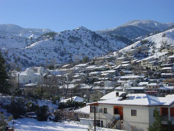


The impressive Troodos mountain range stretches across most of the western side of Cyprus, offering cool sanctuary and idyllic hours spent in long walks in its scented pine forests in summer and winter sports and ski-ing in winter. More information can be found on www.kypros.org/Cyprus/troodos.html
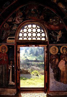
There are nine churches and one monastery in Troodos that are counted among UNESCO's World Heritage Sites and several other monasteries, of which the Kykkos monastery is the richest and most famous. The nine Byzantine churches are:
* Stavros tou Ayiasmati
* Panayia tou Araka
* Timiou Stavrou at Pelendri
* Ayios Nikolaos tis Stegis
* Panayia Podithou
* Assinou
* Ayios loannis Lampadistis
* Panayia tou Moutoula
* Archangel Michael at Pedhoulas
The area has been known since ancient times for its mines, and in the Byzantine period it became a great centre of Byzantine art, as churches and monasteries were built in the mountains, away from the threatened coastline.
Wikipedia article: http://en.wikipedia.org/wiki/Troodos
Nearby cities:
Coordinates: 34°57'57"N 32°55'8"E
- Moutti tou Dia 3.7 km
- Μadhari Mount 4.2 km
- Mount Olympus 6.2 km
- Aetomoutti Mountain 48 km
- Beşparmak Mountains 57 km
- Sulusalma Burnu 142 km
- Markiz Peak - 990 m 270 km
- Tahtali mountain 287 km
- Psalidi mountain 457 km
- Filerimos Hill 462 km
- Karvounas 2.9 km
- Moutti tou Dia 4.6 km
- Amiantos mines 4.7 km
- Kourkoutas Mt. 7.3 km
- Adelfi Forest 8.4 km
- moutti tou kantanappi 10 km
- Mavron Oros 14 km
- Nicosia District 20 km
- Limassol District 23 km
- United Nations Green Line 30 km
Comments