Original Control Tower (Los Angeles, California)
USA /
California /
Del Aire /
Los Angeles, California /
World Way, 1
World
/ USA
/ California
/ Del Aire
World / United States / California
abandoned / shut down, 1962_construction, control tower

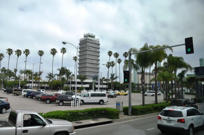
172 feet tall. Completed as the centerpiece of the new LAX in 1961-1962, when the north runway had not as yet been built, and this tower was at the (original) intersection of Lincoln and Sepulveda Boulevards.
This structure served as the LAX control tower from October 1962 to April 1996, at which time it's air traffic control functuctions were taken over by a newer, bigger tower a few hundred yards to the west.
This structure served as the LAX control tower from October 1962 to April 1996, at which time it's air traffic control functuctions were taken over by a newer, bigger tower a few hundred yards to the west.
Nearby cities:
Coordinates: 33°56'40"N 118°23'53"W
- Southern California TRACON (KSCT) 167 km
- NORCAL TRACON 575 km
- Electronic Warfare Range Control 599 km
- Albuquerque Air Route Traffic Control Center (ZAB) 1092 km
- FAA RCAG Beacon Hill 1542 km
- Minuteman III ICBM Launch Control Facility (G-1) 1581 km
- Minuteman III ICBM Launch Control Facility (A-1) 1616 km
- Minuteman III ICBM Launch Control Facility (J-1) 1640 km
- FAA-Houston ARTCC 2218 km
- Minneapolis Air Route Traffic Control Center (KZMP) 2465 km
- Los Angeles International Airport (LAX/KLAX) 0.9 km
- Westchester 1.3 km
- Playa del Rey 3.9 km
- Playa Vista 3.9 km
- Ballona Wetlands 4.7 km
- Del Rey 5.5 km
- Marina del Rey, California 5.7 km
- Ladera Heights, California 6.1 km
- South Bay 11 km
- Los Angeles County, California 37 km