Anjar municipality
Lebanon /
al-Biqaa /
Zahhlah /
World
/ Lebanon
/ al-Biqaa
/ Zahhlah
, 9 km from center (زحلة)
World / Lebanon / Beqaa
municipality, draw only border
A town which was built by a group of Armenians that due to the threats of the Turkish government in 1939 were forced to leave their own homeland MoussaDagh and were driven to the outskirts of Lebanon. There they were given a new piece of land bought by the French government and were left in those mudlands to face their own destiny. It was there, in Anjar, that they started a new life, cultivated, blossomed, and progressed.
(www.mousaleranjar.com)
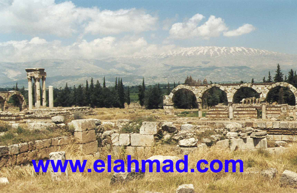
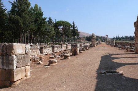
Contains unique ruins of an Umeyyad city (8th century), classified as a World Heritage Site by the UNESCO: whc.unesco.org/en/list/293
almashriq.hiof.no/lebanon/900/910/919/anjar
(www.mousaleranjar.com)
Contains unique ruins of an Umeyyad city (8th century), classified as a World Heritage Site by the UNESCO: whc.unesco.org/en/list/293
almashriq.hiof.no/lebanon/900/910/919/anjar
Nearby cities:
Coordinates: 33°44'18"N 35°55'58"E
- Zahle-Muallaqa-Taanayel municipality 20 km
- Nahle municipality 48 km
- Harbata municipality 61 km
- Nabha municipality 63 km
- Arsal municipality 67 km
- Valley of Springs Regional Council 127 km
- Gilboa Regional Council 138 km
- Megiddo Regional Council 144 km
- Menashe Regional Council 161 km
- Drom HaSharon Regional Council 194 km
- Anjar/Kfar Zabad Hima (Nature reserve) 2 km
- Uniceramic ceramics factory 7 km
- Cascada Village - Bekaa 7 km
- Taanayel 7.6 km
- Haoush el Oumara dependencies 7.8 km
- Muallaqa dependencies 10 km
- Al-Dimas Subdistrict (Nahiyah) 13 km
- Western Bekaa District 19 km
- Mount Lebanon Governorate 27 km
- Rif Dimashq Governorate (PCS) 112 km