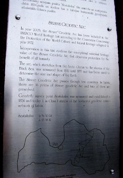
Sestu-Kalns - Struve Geodetic Arc
Latvia /
Aizkraukles /
Plavinas /
World
/ Latvia
/ Aizkraukles
/ Plavinas
World / Latvia / Vidzeme
UNESCO World Heritage Site, geodetic point


Wikipedia article: http://en.wikipedia.org/wiki/Struve_Geodetic_Arc
Nearby cities:
Coordinates: 56°50'24"N 25°38'12"E
- Oranienbaum Bridgehead 401 km
- Gatchina 402 km
- Lomonosov 417 km
- The Sea Channel 424 km
- Kronstadt 425 km
- Petrovsky Fairway 431 km
- Yukky Hills 454 km
- Koltushskaya Hills 455 km
- The Road of Life 489 km
- Kenozersky National Park 914 km
- Biogas power station 3.5 km
- Vecmuižas Lake 5.6 km
- Ērgļi Reservoir 7 km
- Vasejkalns Hill 7.4 km
- Forest 10 km
- Velna klēpis 12 km
- Iņķi 13 km
- Zvanezers Lake 14 km
- Koknese Municipality 18 km
- Šķibes swamp 21 km