Fuglenes - Struve Geodetic Arc (Hammerfest)
Norway /
Finnmark /
Rypefjord /
Hammerfest
World
/ Norway
/ Finnmark
/ Rypefjord
World / Norway / Finnmark
interesting place, UNESCO World Heritage Site, geodetic point


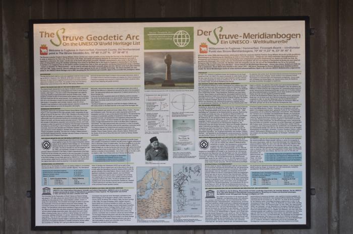
The Struve Arc is a chain of survey triangulations stretching from Hammerfest in Norway to the Black Sea, through 10 countries and over 2,820 km. These are points of a survey, carried out between 1816 and 1855 by the astronomer Friedrich Georg Wilhelm Struve, which represented the first accurate measuring of a long segment of a meridian. This helped to establish the exact size and shape of the planet and marked an important step in the development of earth sciences and topographic mapping. It is an extraordinary example of scientific collaboration among scientists from different countries, and of collaboration between monarchs for a scientific cause. The original arc consisted of 258 main triangles with 265 main station points. The listed site includes 34 of the original station points, with different markings, i.e. a drilled hole in rock, iron cross, cairns, or built obelisks.
Wikipedia article: http://en.wikipedia.org/wiki/Struve_Geodetic_Arc
Nearby cities:
Coordinates: 70°40'12"N 23°39'48"E
- Tanafjord 155 km
- AS Syd-Varanger 264 km
- Pallastunturi 286 km
- Sredny Peninsula 316 km
- Rybachy Peninsula 318 km
- The Moskstraumen 533 km
- Seydozero 538 km
- Werenskioldbreen 761 km
- Hansbreen 762 km
- Kongsøya 931 km
- Kvaløya 8.8 km
- Seiland 29 km
- Rolvsøy 37 km
- Ingøya 46 km
- Havøya 51 km
- Breisundet 54 km
- Hjelmsøya 59 km
- Måsøya 62 km
- Porsangerfjorden 78 km
- Magerøya 87 km