RAF Buchan Radar Station
United Kingdom /
Scotland /
Boddam /
Longhave, Peterhead Aberdeenshire AB42 ONX
World
/ United Kingdom
/ Scotland
/ Boddam
World / United Kingdom / Scotland
military, RAF - Royal Air Force, early warning radar
RAF Buchan is a Royal Air Force station near Peterhead in Aberdeenshire. It has been there since 1952, although the domestic site in Boddam is now closed. The site is home to a Control and Reporting Centre. CRC Buchan, a remote radar site, is capable of coordinating all aspects of air defence in its Area of Responsibility within the United Kingdom's Air Policing Area. It can routinely work closely with similar units in Scandanavia (sic), NATO navies and Airborne Warning and Control aircraft, the CRC provides an accurate Recognised Air Picture and Weapons Control Capability. RAF Buchan also parents Remote Radar Heads Saxa Vord and Benbecula.
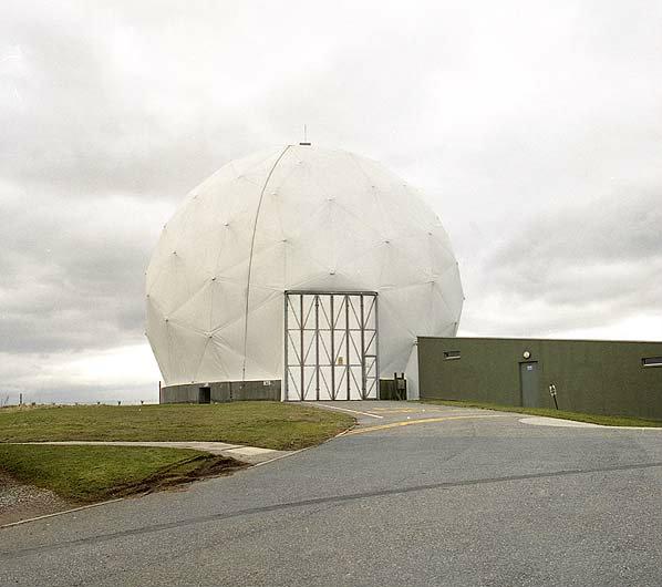
Until 2005 it was also home of one of the two Control and Reporting Centres for the United Kingdom in the form of an impressive two story underground bunker (R3). As such it was responsible for coordinating all aspects of air defence as part of The United Kingdom Air Surveillance and Control System (UK ASACS).The Type 92 radar, now operated remotely, is housed in a pressurized Radome. Until 1994 the base also operated a Type 80 radar and a Westinghouse TPS-34 amongst others.
In 2003 it was announced that permanently manned operations were to cease at RAF Buchan in 2005. At that time the Royal Air Force's now obsolete Integrated Command and Control System would be switched off, and air defence functions would be taken over by the Universal Command and Control System at RAF Boulmer and RAF Scampton. Ultimately, however, Neatishead closed before Buchan following spending reviews. Manned operations formally ceased at RAF Buchan on 26 November 2004 and the domestic site in the nearby village of Boddam was officially downsized on 31 March 2005.
Longhave, Peterhead Aberdeenshire AB42 ONX
www.raf.mod.uk/organisation/stations.cfm?selectStation=...
www.secretscotland.org.uk/index.php/Secrets/RAFBuchan
www.subbrit.org.uk/rsg/sites/b/buchan/
Wikipedia article: http://en.wikipedia.org/wiki/RAF_Buchan
Nearby cities:
Coordinates: 57°27'32"N 1°48'42"W
- Crimond Naval Air Station 19 km
- RAF Lossiemouth 97 km
- RAF Kinloss 109 km
- Barrybudden Training Camp 123 km
- RAF Leuchars 136 km
- RAF Tain - Defence Training Estates 138 km
- DM (frmr RNAD) Glen Douglas 232 km
- Remains of Royal Ordnance Factory 240 km
- RNAD Coulport 243 km
- Hebrides Missile Test Range 336 km
- St. Fergus Gas Terminal 13 km
- Sands of Forvie Nature Reserve 18 km
- Loch of Strathbeg RSPB 18 km
- Crimond Naval Air Station 18 km
- Blackbar dunes 20 km
- Haddo Estate 25 km
- Former RAF Banff 1943 - 1945 54 km
- Knock Hill 59 km
- Aberdeenshire Council 64 km
- Moray Council 84 km