Natural Reserve Parque Luro
Argentina /
La Pampa /
Santa Rosa /
World
/ Argentina
/ La Pampa
/ Santa Rosa
World / Argentina / La Pampa
park, nature conservation park / area
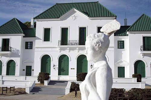
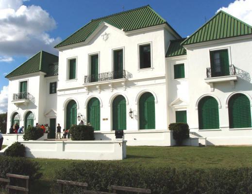
PARQUE LURO Natural Reserve is a provincial reserve, and was declared a Protected Area with no exploitation of its natural resources in May 30, 1996. Later in July 25, 1997 it was proclaimed Natural and Cultural Heritage. Through the provincial decree Nº 762 / 78, the Tourism Undersecretaryship was assigned 1600 hectares to be used for tourism and recreation, while Natural Resourses Management was assigned 6000 hectares with the purpose of conservation and scientific research. Both organizations belong to the Provincial government. The natural beauty of this area conveys an icon in the touristic offer of the province, given its peculiar landscapes. Three natural environments can be brought to attention: the woods, the lagoon, and the dunes. These three offer exotic fauna such as the red deer and the European wild boar. Also, 160 different (migratory and resident) bird species have been registered. It is of great importance too the rich history of the place. At the turn of the 20 th century, the park became the first game preserve in the country. At that time it was known as “San Huberto”. It served as the gathering place for a number of important figures in times when they were deciding about the provincialization of the territory. The most outstanding feature is “El Castillo” (The Castle) Museum, which was declared National Historical Monument, and other historical buildings such as “El Tanque del Millón” (The Million Tank), “El Tambo Modelo” (The Model Diary Farm) and “La Sala de Carruajes” (The Carriage Room).
Nature Characteristics
PARQUE LURO Natural Reserve is placed on the phyto-geografical area of the “espinal” (thorn bushes). The predominant tree is the calden. The area is a valley with notorious differences in hight (up to 80 meters). It has warm weather with temperatures oscillating between 35ºC and (-)8ºC. Heavy rains, especially in October and November, diminishing in summer and reaching 80 mm. in March. Northern winds affect the region, mainly during springtime. The relative humidity is low. The soil mainly sandy, clayey in low areas. As a consequence of all this, plants have small leaves with thorns. Among the various tree species we can find caldenes, algarrobos (carobs), sombra de toro and chañar. Among the bushes, piquillín, llaollín, molle, zampa, and jume. There is also abundance of gramineae: flechilla negra, unquillo, pasto crespo, and pasto puna are the most common. The native fauna is conformed by armadillos, foxes, pumas, wild cats, and ferrets among others. Different species were brought to this area, such as deers and wild boars. The indigenous bird species are: calandra larks, quejones, turkey buzzards, woodpeckers, chincheros, churrinches, and loicas.
Nearby cities:
Coordinates: 36°55'24"S 64°13'37"W
- San Fernando District (Islands Sector) 589 km
- Samborombón Bay 623 km
- Taim Ecological Station 1121 km
- Copo National Park 1270 km
- Lagoa do Peixe National Park 1370 km
- Calilegua National Park 1502 km
- Iguaçu National Park 1615 km
- Baritú National Park 1616 km
- Ilha Grande National Park 1794 km
- Juréia-Itatins Ecological Station 2124 km
- Cemetery 29 km
- Barrio Fonavi 42 32 km
- Circuito de la Escuela Municipal de Conducción 35 km
- Cemetery 36 km
- Santa Rosa Airport 37 km
- Club de planeadores de Santa Rosa 37 km
- Runway 01/19 38 km
- Thames 83 km
- Lagoon 95 km
- Salliqueló Partido 109 km