Grave of Meriwether Lewis
USA /
Tennessee /
Hohenwald /
World
/ USA
/ Tennessee
/ Hohenwald
World / United States / Tennessee
cemetery, historic landmark
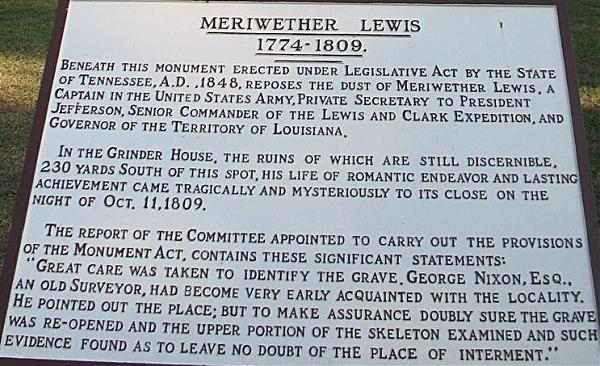

Co-leader of the Lewis and Clark expedition.
Nearby cities:
Coordinates: 35°30'40"N 87°27'37"W
- J.L.M. Curry House 262 km
- Fort Toulouse Jackson Park 350 km
- Fort Mitchell Historic Site 417 km
- Spring Grove Cemetery and Arboretum 484 km
- Indianapolis Motor Speedway (IMS) 490 km
- Cooleemee Plantation 638 km
- The Greenbrier 682 km
- The Omni Homestead Resort 735 km
- Hampton Plantation 779 km
- Bethlehem Steel - Johnstown Works 922 km
- Natchez Trace Pkwy Interchange 44.20 0.6 km
- Natchez Trace Parkway Bridge 4.3 km
- Natchez Trace Pkwy Interchange 49.50 7.6 km
- Fall Hollow Campground 7.9 km
- Walmart Supercenter 8 km
- The Farm (intentional community) 12 km
- Apple Orchard 13 km
- Well Cemetery 24 km
- Maury County Airport, Columbia/Mt Pleasant, TN (MRC/KMRC) 26 km
- Natchez Trace Pkwy Interchange 66.35 30 km
Natchez Trace Pkwy Interchange 44.20
Natchez Trace Parkway Bridge
Natchez Trace Pkwy Interchange 49.50
Fall Hollow Campground
Walmart Supercenter
The Farm (intentional community)
Apple Orchard
Well Cemetery
Maury County Airport, Columbia/Mt Pleasant, TN (MRC/KMRC)
Natchez Trace Pkwy Interchange 66.35