The Storr
United Kingdom /
Scotland /
Portree /
World
/ United Kingdom
/ Scotland
/ Portree
World
rocks
Add category
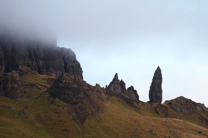
The Storr is a rocky hill on the Trotternish peninsula of the Isle of Skye. The hill presents a steep rocky eastern face overlooking the Sound of Raasay, contrasting with gentler grassy slopes to the east.
The Storr is prime example of the Trotternish landslip, the longest such feature in Great Britain.
The area in front of the cliffs of The Storr is known as The Sanctuary. This has a number of weirdly shaped rock pinnacles, the remains of ancient volcanic plugs. One of the most famous of these is known as The Old Man of Storr.
A well constructed path, used by many sightseers, leaves the A855 just north of Loch Leathan. It heads up through an area of forestry, with glimpses of the scenery beyond. After about 1.5 km the walker emerges from the trees, into a spectacular, almost lunar, landscape.
Most day-trippers are content simply to wander around The Sanctuary, admiring the pinnacles and gazing up at cliffs of The Storr. Walkers can easily ascend to the summit however by skirting below the cliffs whilst heading north. After passing over a fence and climbing a brief steep section of loose rock, the main ridge is reached. This can then be followed by doubling back and heading southwards, climbing towards the summit.
The Storr is often climbed as part of a much longer expedition, following the full length of the Trotternish landslip.
From 1 August to 17 September 2005 one of Britain's single largest environmental artworks was staged on the walk up to Coire Faoin at the base of The Old Man of Storr and the Storr cliffs. Created by nva, a Scottish environmental arts company directed by Angus Farquhar (formerly of Test Dept) and designed by a team including "<slight>" and David Bryant, the work contained music by Geir Jenssen, Paul Mounsey, live performance by Gaelic singer Ann Martin and recordings of the works of Gaelic poet Somhairle MacGill-Eain (Sorley MacLean).
Nearby cities:
Coordinates: 57°30'26"N 6°10'34"W
- The Parallel Roads of Glen Roy 101 km
- Hoggs of Oxna 401 km
- Ve Skerries 406 km
- Munkurin 429 km
- Eyian Rock 1091 km
- Hólmar 1127 km
- Skarfasker 1178 km
- Löngusker 1181 km
- Stórhraunseyjar 1186 km
- Hornbjarg 1303 km
- Rona 13 km
- Raasay 13 km
- Meall na Suiramach (The Quiraing) 16 km
- Isle of Skye 19 km
- Loch Dunvegan 28 km
- Shiant Isles 44 km
- Harris 60 km
- The Minch 65 km
- Taransay 67 km
- Isle of Lewis 83 km