Планината Ртан
Serbia and Montenegro /
Central Serbia /
Sokobanja /
World
/ Serbia and Montenegro
/ Central Serbia
/ Sokobanja
, 9 км от центъра (Сокобанйа)
планина, парк, невидим обект

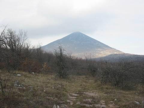

Rtanj Mountain is a mountain situated in east Serbia, approximately 200 km southeast of Belgrade, next to Boljevac. Belonging to the Carpathian mountains, its highest peak is Siljak (1,565 m), a natural phenomenon of karst terrain.
The north side of the mountain is covered with forests and shrubs, full of autochthonous plant species and plenty of sources of potable water. A hunting ground is located on 6368ha. The most common prey are roe deer and wild pigs.
According to a legend, the castle of a wizard was situated on Rtanj Mountain, in which a great treasure was guarded. However, the castle has disappeared and on the peak Siljak, there is a now little chapel dedicated to St. George. It was built in 1932 by the wife of a former local miner. Today, the chapel is in ruins, as it was partly destroyed by dynamite, when treasure hunters tried to find the hidden gold. Today, there is an initiative to reconstruct the chapel.
Wikipedia article: en.wikipedia.org/wiki/Rtanj_Mountain
Nearby cities:
Координати: 43°43'17"N 21°54'33"E
- Тупижница 19 км
- Свърлиг 36 км
- Суха планина 43 км
- Планина Ястребац 66 км
- Мали Кърш 66 км
- Белава 67 км
- Дели Йован 69 км
- Гледачка планина 89 км
- Голия 139 км
- Златибoр 187 км
- Община Сокобаня 7.5 км
- Соко баня 9 км
- Община Болевац 16 км
- Зоруновац 20 км
- Тупижница 21 км
- Вина 22 км
- Община Алексинац 27 км
- Община Свърлиг 34 км
- Община град Зайчар 39 км
- Община Княжевац 40 км