Río de la Plata
Uruguay /
Colonia /
Juan Lacaze /
World
/ Uruguay
/ Colonia
/ Juan Lacaze
World / Uruguay / Canelones
bay
Add category
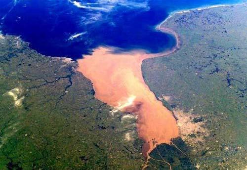
The Río de la Plata (Spanish: "Silver River") — which is often referred to in English-speaking countries as the River Plate (as in the Battle of the River Plate), or sometimes as the [La] Plata River — is the estuary formed by the combination of the Uruguay River and the Paraná River. It is a funnel-shaped indentation on the southeastern coastline of South America, extending 290 kilometres (180 mi) from the rivers' confluence to the Atlantic Ocean.
Wikipedia article: http://en.wikipedia.org/wiki/Río_de_la_Plata
Nearby cities:
Coordinates: 35°10'36"S 56°44'24"W
- Samborombón Bay 66 km
- Itapocoroy Bay 1217 km
- Babitonga Bay 1261 km
- x 1402 km
- Bay of Concepción 1483 km
- Arauco Gulf 1526 km
- Corral Bay 1562 km
- Moreno Bay 1866 km
- Gulf of Taraco 2414 km
- Gulf of Achacachi 2462 km
- Wreck of German pocket battleship Admiral Graf Spee 47 km
- Dry dock 53 km
- Club de Golf de el Cerro 53 km
- Fusileros Navales (Fusna) 53 km
- Barrio Casabó 53 km
- Parque Vaz Ferreira 54 km
- La Planchada, a los pies el Río de la Plata, con toda la banda de Rampla Los Guatusi 54 km
- Escuela Checoslovaquia 55 km
- colegio santa clara 55 km
- Cerro 55 km
Comments