Mount Sundoro 3,150 meter
Indonesia /
Jawa Tengah /
Parakan /
World
/ Indonesia
/ Jawa Tengah
/ Parakan
World / Indonesia / Jawa Tengah
mountain, volcano

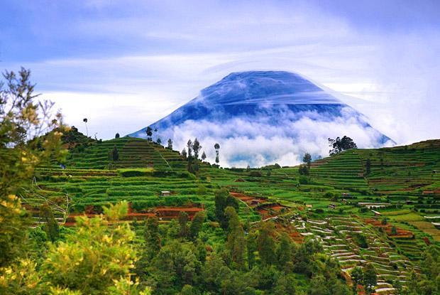
Mount Sundoro or Mount Sindoro is a stratovolcano located close to Sumbing Volcano. It is one of the most symmetrical volcanoes in Java.
Craters at the summit area : Segoro Wedi, Segoro Banjaran, Kawah utara, kawah selatan and Sumur ledakan.
Hundreds of hills on the NE side of the mountain are remnants of ancient landslides and lahars.
Eruptions have historically produced ash plumes rising from the summit which were visible for tens of kilometers. However, no record of volcanic ash on the ground has been found, indicating ash was too thin to be preserved.
www.volcanolive.com/sundoro.html
Wikipedia article: http://en.wikipedia.org/wiki/Mount_Sundoro
Nearby cities:
Coordinates: 7°17'58"S 109°59'52"E
- Pegunungan Kunci Potorondo 18 km
- Giyanti Mountain 20 km
- Dieng Plateau Area 24 km
- Pegunungan Maung 31 km
- Mount Muria 123 km
- Mount Lawu (3267m) 133 km
- Wilis Mountain 183 km
- Mt. Liman (2.563 m) 197 km
- Mount Kelud 1,731 m 257 km
- Gunung Anjasmoro 2.277 m 273 km
- Mt. Kembang 2.7 km
- Sikatok Tea Plantation 3 km
- Gunung Watu 4.5 km
- Blemben Tea Plantation 4.6 km
- Bedakah Tea Plantation 5.5 km
- Anggrunggondok 5.7 km
- Kledung Pas 5.8 km
- Sontonayan 6.4 km
- Kecamatan Ngadirejo 7.7 km
- Central Java (Jawa Tengah) 13 km
Comments