Tosno
Russia /
Leningrad /
Tosno /
World
/ Russia
/ Leningrad
/ Tosno
, 1 km from center (Тосно)
World / Russia / Leningrad
city, district center
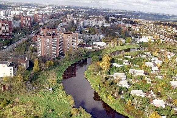


Town and the administrative center of Tosnensky District in Leningrad Oblast, Russia, located on the Tosna River, 53 kilometers (33 mi) southeast of the center of St. Petersburg. Population: 39,101 (2010 Census).
The village of Tosno was first mentioned in Russian chronicles in 1500. It was a part of Vodskaya Pyatina, one of the five pyatinas into which Novgorod Lands were divided. In the course of the administrative reform carried out in 1708 by Peter the Great, Tosno was included into Ingermanland Governorate (known since 1710 as St. Petersburg Governorate). Its development in the 18th and 19th centuries was mainly due to its geographic location on the road between the two Russian capitals. From 1774, it was a station at the yam route. In 1849, the railway connecting Tosno with St. Petersburg and Chudovo opened. In the 19th century, Tosno was a part of Tsarskoselsky Uyezd (renamed in 1918 Detskoselsky Uyezd); the governorate was accordingly renamed Petrogradsky in 1913 and Leningradsky in 1924). On August 1, 1927, the uyezds were abolished and Kolpinsky District, with the administrative center in the town of Kolpino, was established. The governorates were also abolished and the district became a part of Leningrad Okrug of Leningrad Oblast. Tosno became a part of Kolpinsky District. On August 19, 1930, Kolpinsky District was abolished and Tosno became the administrative center of newly established Tosnensky District. On August 20, 1935, Tosno was granted urban-type settlement status. Between August 28, 1941 and January 26, 1944, during World War II, Tosno was occupied by German troops and largely destroyed, but rebuilt after the war. On February 1, 1963, Tosno was granted town status.
The village of Tosno was first mentioned in Russian chronicles in 1500. It was a part of Vodskaya Pyatina, one of the five pyatinas into which Novgorod Lands were divided. In the course of the administrative reform carried out in 1708 by Peter the Great, Tosno was included into Ingermanland Governorate (known since 1710 as St. Petersburg Governorate). Its development in the 18th and 19th centuries was mainly due to its geographic location on the road between the two Russian capitals. From 1774, it was a station at the yam route. In 1849, the railway connecting Tosno with St. Petersburg and Chudovo opened. In the 19th century, Tosno was a part of Tsarskoselsky Uyezd (renamed in 1918 Detskoselsky Uyezd); the governorate was accordingly renamed Petrogradsky in 1913 and Leningradsky in 1924). On August 1, 1927, the uyezds were abolished and Kolpinsky District, with the administrative center in the town of Kolpino, was established. The governorates were also abolished and the district became a part of Leningrad Okrug of Leningrad Oblast. Tosno became a part of Kolpinsky District. On August 19, 1930, Kolpinsky District was abolished and Tosno became the administrative center of newly established Tosnensky District. On August 20, 1935, Tosno was granted urban-type settlement status. Between August 28, 1941 and January 26, 1944, during World War II, Tosno was occupied by German troops and largely destroyed, but rebuilt after the war. On February 1, 1963, Tosno was granted town status.
Wikipedia article: http://en.wikipedia.org/wiki/Tosno
Nearby cities:
Coordinates: 59°32'47"N 30°52'15"E
- Saint Petersburg 112 km
- Petrozavodsk 317 km
- Espoo (City) 366 km
- Kangasala 444 km
- Tampere 473 km
- Ylöjärvi 491 km
- Sastamala 520 km
- Alavus centre 534 km
- Arkhangelsk 759 km
- Nizhny Novgorod 823 km
- prospekt Lenina, 14 0.2 km
- Rabochaya ulitsa, 10 0.2 km
- prospekt Lenina, 19 0.4 km
- ulitsa Chekhova, 8 0.5 km
- Kindergarten 0.6 km
- Moy Dom hypermarket 1.2 km
- Hypermarket parking 1.3 km
- Tosno railway station 1.4 km
- Tosno-2 1.8 km
- Tosnensky district 21 km