Lamon Bay
Philippines /
Southern Tagalog /
Tignoan /
World
/ Philippines
/ Southern Tagalog
/ Tignoan
World / Philippines / Quezon / Tayabas City
water, bay, invisible
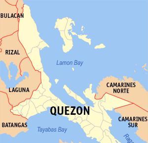
Lamon Bay is a large bay in the southern part of Luzon island, Philippines, at 14.4166667°N 122°E. It is a body of water connecting the southern part of Quezon province to the Pacific Ocean, and bounds the coastal towns of Atimonan, Gumaca, Plaridel, Lopez, Calauag, and the islands of Alabat. It is a rich fishing ground and the home of various living corals. Most parts of the bay consist of gray sand, some parts are filled with rocks, and other living corals. It is gradually sloping to the extend that, during low tide, the water level is low enough to allow one to walk as far as five hundred metres from the shore. The beaches in the towns of Gumaca and Plaridel are sandy and ideal for swimming. In some parts of the bay, about ten feet from the beach front, are living corals. The town of Lopez has the best colonies of corals which are located just about 15 minutes by boat from the shore. Lamon Bay is located at the southern part of Quezon.
Wikipedia article: http://en.wikipedia.org/wiki/Lamon_Bay
Nearby cities:
Coordinates: 14°29'14"N 121°49'6"E
- Lamon Bay 28 km
- Calauag Bay 31 km
- Tayabas Bay 71 km
- Ragay Gulf 91 km
- Manila Bay 137 km
- San Miguel Bay 141 km
- Casiguran Sound 198 km
- Asid Gulf 303 km
- Pandan Bay 303 km
- Lingayen Gulf 305 km
- PH Tibag River MHP 20 km
- PH Piapi MHP 21 km
- Cagbalete Island, Quezon 23 km
- Nilandingan Cove 23 km
- MVT Santo Niño Beach Resort 24 km
- Santo Niño Beach Resort 24 km
- Cagbalete Strait 25 km
- Aquazul Resort & Hotel 25 km
- Province of Quezon 41 km
- Laguna 56 km