Solomon's Stables (Jerusalem)
Israel /
Jerusalem /
Jerusalem
World
/ Israel
/ Jerusalem
/ Jerusalem
World / Palestinian territories / West Bank
archaeological site, prayer ground / prayer hall, underground facility
Al-Marwani Mushalla
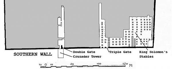
Underground structure in the south-east of the Temple Mount. Twelve rows of galleries were originally storage areas of the Second Temple. Now using as Muslim prayer hall
Underground structure in the south-east of the Temple Mount. Twelve rows of galleries were originally storage areas of the Second Temple. Now using as Muslim prayer hall
Wikipedia article: http://en.wikipedia.org/wiki/Solomon's_Stables
Nearby cities:
Coordinates: 31°46'34"N 35°14'12"E
- Military Underground Command Base 325 km
- Underground Military Facility (Rumored) 338 km
- Underground Military Facility (Rumored) 338 km
- Bunkers 341 km
- Quarry Simon Elsweese 347 km
- Early warning radars 376 km
- New Long-Range Missile Facility 387 km
- Military Communications Base Near Tanta Airbase 421 km
- Airbase Command / Control Facilities And "Bunker Town" 449 km
- "Bunker Town" 721 km
- Kidron Valley 0.3 km
- The Old City of Jerusalem 0.5 km
- Mount of Olives Jewish Cemetery 0.5 km
- Mount Moriah 0.6 km
- Mount Zion 0.7 km
- Mount of Olives 0.9 km
- East Jerusalem 1.6 km
- Gush Etzion 13 km
- Judea and Samaria ("West Bank") 19 km
- Judea 24 km
Comments