Canadian Malartic Property
Canada /
Quebec /
Malartic /
Route de Saint-Phillippe (R-117 - Trans-Canada Highway)
World
/ Canada
/ Quebec
/ Malartic
World / Canada / Québec / Vallée-de-l'Or
village, mine, mining, gold mine
This is the property boundary of the Canadian Malartic Mine. Osisko Mining Corporation purchased the property in 2004 and opend the mine. In June 2014, Yamana Gold Inc. and Agnico Eagle Mines Limited acquired all issued and outstanding common shares of Osisko. Partners Agnico Eagle and Yamana Gold have formed a joint committee called Canadian Malartic GP to operate the Mine. Each company has a 50% interest.
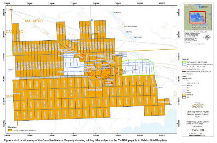
The Property consists of a contiguous block comprising 1 mining concession, 5 mining leases, and 208 mining claims covering an aggregate area of 8,735.9 hectares. The mining claims, mining leases and mining concession are all held, completely or partially, by Canadian Malartic GP.
The Canadian Malartic property lies within the Abitibi Subprovince (Abitibi Greenstone Belt) of the Archean Superior craton, eastern Canada, along the Cadillac–Larder Lake Fault Zone. The rocks in the Canadian Malartic property are predominantly composed of metavolcanic rocks, metasedimentary rocks, and related intrusions.
Mineralization in the Canadian Malartic deposit occurs as a continuous shell of 1 to 5% disseminated pyrite associated with fine native gold and traces of chalcopyrite, sphalerite and tellurides. The gold resource is mostly hosted by altered clastic sediments of the Pontiac Group (70%) overlying an epizonal dioritic porphyry intrusion. A portion of the deposit also occurs in the upper portions of the porphyry
body (30%).
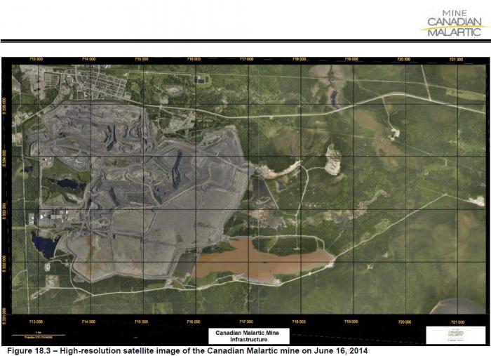
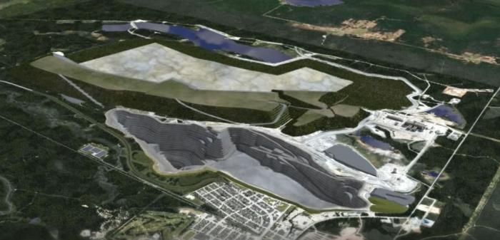
The Canadian Malartic mine is a large open pit operation comprising the Canadian Malartic, Barnat and Gouldie pits. In order to maximize productivity and limit the number of units operating in the pit, large scale equipment was selected for the mine operation. The primary loading tools are hydraulic excavators, with a wheel loader added as a secondary loading tool for the Caterpillar 793F rigid trucks with 227t payloads.
The ultimate Canadian Malartic Pit outline required several blocks of the southern portion of the town of Malartic to be relocated to the north end of town. This included 200 homes, construction of five new institutional buildings, including an elementary school, a day care facility, a long-term health care facility, an adult learning center and a cultural/recreational center. Pre-stripping of the future mine site started in November 2010.
The Property consists of a contiguous block comprising 1 mining concession, 5 mining leases, and 208 mining claims covering an aggregate area of 8,735.9 hectares. The mining claims, mining leases and mining concession are all held, completely or partially, by Canadian Malartic GP.
The Canadian Malartic property lies within the Abitibi Subprovince (Abitibi Greenstone Belt) of the Archean Superior craton, eastern Canada, along the Cadillac–Larder Lake Fault Zone. The rocks in the Canadian Malartic property are predominantly composed of metavolcanic rocks, metasedimentary rocks, and related intrusions.
Mineralization in the Canadian Malartic deposit occurs as a continuous shell of 1 to 5% disseminated pyrite associated with fine native gold and traces of chalcopyrite, sphalerite and tellurides. The gold resource is mostly hosted by altered clastic sediments of the Pontiac Group (70%) overlying an epizonal dioritic porphyry intrusion. A portion of the deposit also occurs in the upper portions of the porphyry
body (30%).
The Canadian Malartic mine is a large open pit operation comprising the Canadian Malartic, Barnat and Gouldie pits. In order to maximize productivity and limit the number of units operating in the pit, large scale equipment was selected for the mine operation. The primary loading tools are hydraulic excavators, with a wheel loader added as a secondary loading tool for the Caterpillar 793F rigid trucks with 227t payloads.
The ultimate Canadian Malartic Pit outline required several blocks of the southern portion of the town of Malartic to be relocated to the north end of town. This included 200 homes, construction of five new institutional buildings, including an elementary school, a day care facility, a long-term health care facility, an adult learning center and a cultural/recreational center. Pre-stripping of the future mine site started in November 2010.
Nearby cities:
Coordinates: 48°9'47"N 78°6'38"W
- Canadian Malartic Open Pit - 2014 8.5 km
- Val-d’Or 22 km
- Lac Herbin Property 27 km
- Bachelor Lake Property 204 km
- Detour Lake Property (Ont.) 249 km
- Chibougamau Property 336 km
- Eleonore Property 527 km
- IOC - Carol Lake mine 955 km
- Silver Yard, Labrador Iron Ore mines 1067 km
- Raglan 1534 km
- East-Amphi Site 3.3 km
- East-Amphi open pit 3.5 km
- Canadian Malartic Open Pit - 2014 3.6 km
- Canandian Malartic Open Pit 3.7 km
- Mill 5.7 km
- Tailings Storage Site PR4 5.8 km
- Orica plant 6.8 km
- Southeast Pond 6.8 km
- Lapa Mine Property 13 km
- Poste Pandora 16 km