Banshkhali Upazila (বাঁশখালী উপজেলা)
Bangladesh /
Chattagam /
Satkaniya /
World
/ Bangladesh
/ Chattagam
/ Satkaniya
World / Bangladesh / Chittagong / Chittagong / Cox's Bazar
subdistrict, fourth-level administrative division, local government
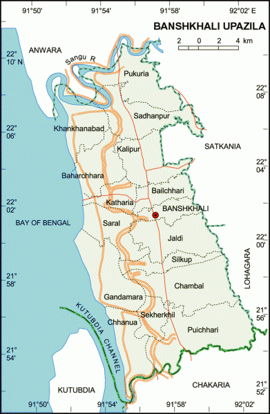
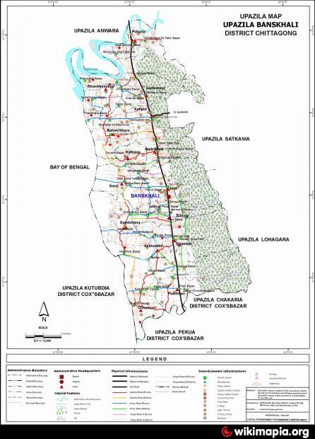
Banshkhali Upazila (Chittagong district) with an area of 376.90 sq km, is bounded by Anwara upazila and Sangu river on the north, Chakaria upazila on the south, Lohagara and Satkania upazilas and wide hilly regions on the east, Kutubdia Channel, Kutubdia upazila and bay of Bengal on the west.
The location of Banskhali town is 22.0015666N 91.952219E. Banshkhali (Town) consists of one mouza. It has an area of 8.86 sq km. The town has a population of 15763; male 51.74%, female 48.26%; population density per sq km 1779. Literacy rate among the town people is 28.7%. The town has one dakbungalow.
Banshkhali thana, now an upazila, was established in 1958. The upazila consists of 15 union parishads, 69 mouzas and 111 villages.
Archaeological heritage and relics: Baksi Hamid Mosque and its Arabic stone inscriptions (1558).
Religious institutions: Mosque 464, Eidgah, 103, temple 52, kyang 2 and church 1, most noted of which are Habibullah Khan Jami Mosque, Katebi Jami Mosque.
As of the 1991 Bangladesh census: Population 320339; male 52.07%, female 47.93%; Muslim 85.44%, Hindu 13.23%, Buddhist 1.13% and others 0.2%.
Literacy and educational institutions: Average literacy 22.6%; male 28.3%, female 16.5%. Educational institutions: college 4, high school 24, madrasa 241, government primary school 110, non-government primary school 31. Noted educational institutions: Banigram Primary School (1881), Banigram Sadhanpur High School (1917).
Cultural organisations: Library 1, rural club 73, women's organisation 9, playground 24.
Main occupations: Agriculture 33.69%, fishing 2.74%, forestry 1.59%, industry 1.15%, agricultural labourer 27.71%, wage labourer 5.76%, service 5.24%, commerce 10.39%, others 11.73%.
Land use: Total cultivable land 39194.331 hectares; single crop 33%, double crop 37.20%, treble crop 29.80%. Cultivable land under irrigation 80%.
Land control: Among the peasants 24% are landless, 32% small, 28% intermediate and 16% rich.
Fisheries, dairies, poultries Fishery 34, poultry 86, hatchery 25.
Communication facilities- Roads: pucca 27 km, semi pucca 47 km and mud road 540 km.
Manufactories: Saw mill 15, ice cream factory 3, brickfield 5, welding 6.
Cottage industries: Bamboo work 24, goldsmith 178, blacksmith 22, potteries 478, wood work 78, tailoring 165, bidi factory 3.
NGO activities: Operationally important NGOs are CARE, Red Crescent Society, proshika, brac, Uddipan, Codec, Prottasi, Urban, DORP, HEED Bangladesh, Green Bangladesh, asa, Gano Unnayan Prochesta, Ahsania Mission, Shanirvor, Gunagori Mohila Samity, Protishroti and Nari Moitree.
Health centres: Upazila health complex 1, family planning centre 3, satellite clinic 3
Nearby cities:
Coordinates: 22°1'9"N 91°56'16"E
- Chandanaish Upazila 29 km
- Anwara Upazila (আনোয়ারা) 30 km
- Patiya Upazila (পটিয়া) 40 km
- Sandwip 85 km
- Fatikchhari Upazila (ফটিকছড়ি উপজেলা) 113 km
- Ramgati Upazila HQ 130 km
- Kamalnagar Upazila HQ 141 km
- Meghna Upazila 228 km
- Rupganj Upazila 259 km
- Dhobaura Upazila 389 km
- Dream Project 4.4 km
- Shilkup Echo Park (Bam & Daner Chara) 6.1 km
- HRISHIDHAM TEMPLE 7.2 km
- md. emran abu siddique bahrain defence force 12 km
- internet pra 13 km
- B A R A H A T I A 13 km
- Amirabad Bottoli 16 km
- PADUA STATION-akn 18 km
- Chattogram District Area 50 km
- Bandarban District 52 km
Comments