Musasir - Ancient Mannaeans City (Rabat)
Iran /
Azarbayejan-e Gharbi /
Sardasht /
Rabat
World
/ Iran
/ Azarbayejan-e Gharbi
/ Sardasht
, 5 km from center (سردشت)
ancient, castle ruins, place with historical importance, archaeological site, ancient civilization
video :
www.negahmedia.ir/media/show_video/5112
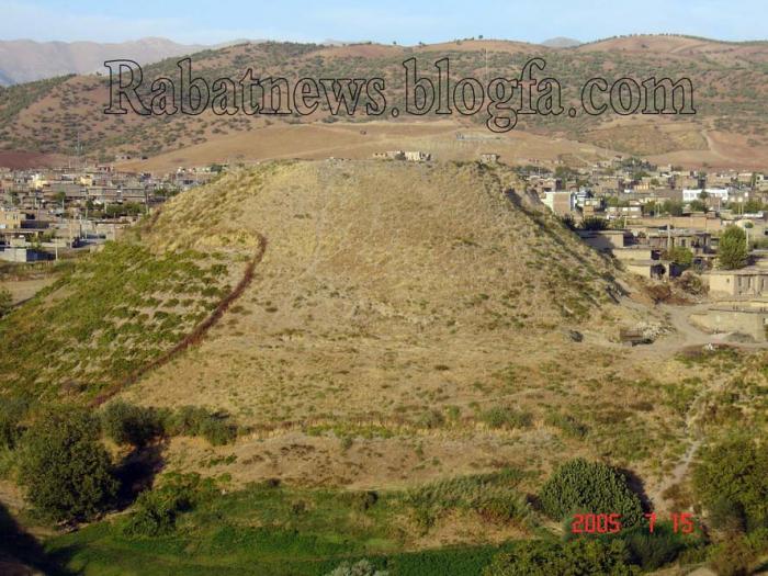
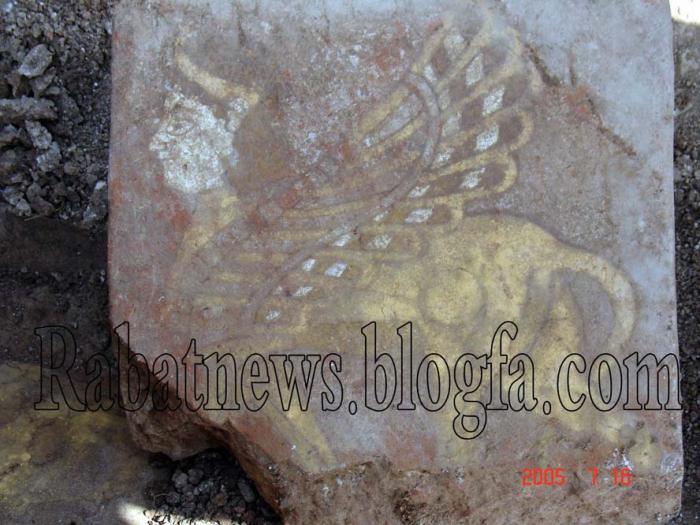
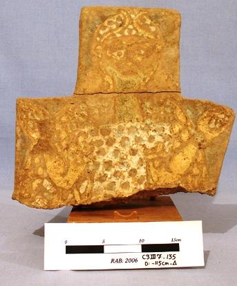
Muṣaṣir (Armenian: Մուծածիր, Assyrian KURMu-ṣa-ṣir and variants, including Mutsatsir, Akkadian for Exit of the Serpent/Snake ), in Urartian Ardini (likely from Armenian Artin) was an ancient city of Urartu, attested in Assyrian sources of the 9th and 8th centuries BC.
photo :
www.rabatnews.blogfa.com/post-37.aspx
It was acquired by the Urartian King Ishpuini ca. 800 BC (see the Kelashin Stele). The city's tutelary deity was dḪaldi. The name Musasir in Akkadian means exit of the serpent.
en.wikipedia.org/wiki/Mannaeans
The city's location is not known with certainty, although there are a number of hypotheses, all in the general area of 36°N 46°E, in the Zagros south of Lake Urmia. François Thureau-Dangin tentatively located it at Mudjesir, 10 km west of Topzawa. Reza Heidari, an archaeologist of the "Cultural Heritage and Tourism Organization" of Iran's West Azarbaijan Province claims Rabat Tepe near Sardasht, Iran as the location of Muṣaṣir. Lynch claimed that it was close to the modern town of Rowanduz in Iraqi Kurdistan
fatemenaderi.blogfa.com/post/4
www.negahmedia.ir/media/show_video/5112
Muṣaṣir (Armenian: Մուծածիր, Assyrian KURMu-ṣa-ṣir and variants, including Mutsatsir, Akkadian for Exit of the Serpent/Snake ), in Urartian Ardini (likely from Armenian Artin) was an ancient city of Urartu, attested in Assyrian sources of the 9th and 8th centuries BC.
photo :
www.rabatnews.blogfa.com/post-37.aspx
It was acquired by the Urartian King Ishpuini ca. 800 BC (see the Kelashin Stele). The city's tutelary deity was dḪaldi. The name Musasir in Akkadian means exit of the serpent.
en.wikipedia.org/wiki/Mannaeans
The city's location is not known with certainty, although there are a number of hypotheses, all in the general area of 36°N 46°E, in the Zagros south of Lake Urmia. François Thureau-Dangin tentatively located it at Mudjesir, 10 km west of Topzawa. Reza Heidari, an archaeologist of the "Cultural Heritage and Tourism Organization" of Iran's West Azarbaijan Province claims Rabat Tepe near Sardasht, Iran as the location of Muṣaṣir. Lynch claimed that it was close to the modern town of Rowanduz in Iraqi Kurdistan
fatemenaderi.blogfa.com/post/4
Wikipedia article: http://en.wikipedia.org/wiki/Musasir
Nearby cities:
Coordinates: 36°12'32"N 45°32'58"E
- Ghaterchi Canyon 192 km
- Zahhak Canyon 193 km
- Mount Behistun 260 km
- Ali-Sadr Cave 261 km
- Zangezur National Park 346 km
- Tape Zaghe & Tape Ghabrestan & Ghare Tape- 7000 BC 398 km
- Kashatagh Province 416 km
- Ancient city of Eyvan-e Karkhe 490 km
- Ruin of Gondishapur 512 km
- Great Wall of Gorgan (A Sassanian defence wall and fortification lies on the opposite) 768 km
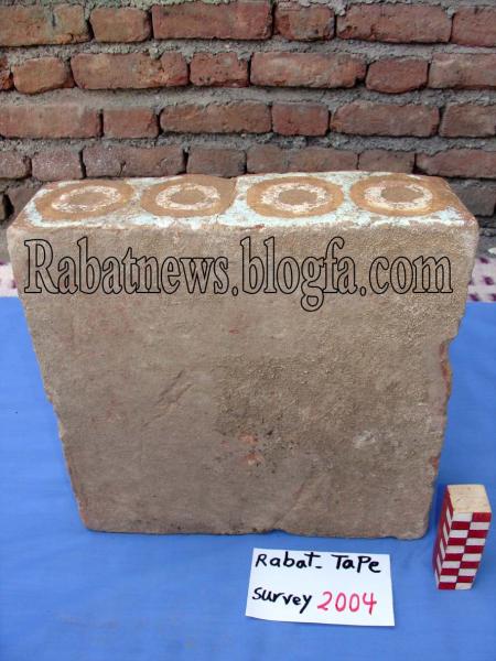
- Tape Rabat no. 1 - Anciant Mannaeans Tample 0.7 km
- Kani Gravan Mineral springs 2 km
- ده شتی که رشیری 12 km
- باغ ره ز و ملکی عه ولای مام حسنی پاراستان 12 km
- HydroElectric Dam, Sardasht county گشايش سد برق آبي سردشت ايران 14 km
- قوذه گان بلاشه گان پکه وپولمده دیناران بناوی 21 km
- gorga vel 21 km
- گان بلاشه 21 km
- ملکی کاک ابراهیمی ملا حسن 22 km
- Slemani Province 88 km
Tape Rabat no. 1 - Anciant Mannaeans Tample
Kani Gravan Mineral springs
ده شتی که رشیری
باغ ره ز و ملکی عه ولای مام حسنی پاراستان
HydroElectric Dam, Sardasht county گشايش سد برق آبي سردشت ايران
قوذه گان بلاشه گان پکه وپولمده دیناران بناوی
gorga vel
گان بلاشه
ملکی کاک ابراهیمی ملا حسن
Slemani Province