Mirsharai Upazila HQ
Bangladesh /
Feni /
Chhagalnaiya /
World
/ Bangladesh
/ Feni
/ Chhagalnaiya
World / Bangladesh / Chittagong / Chittagong / Chittagong
township, subdistrict, fourth-level administrative division, local government
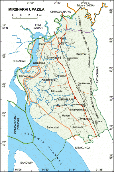
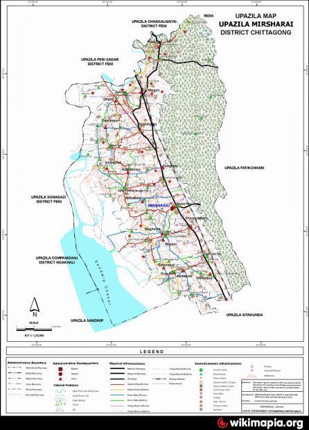
Mirsharai Upazila (Chittagong district) with an area of 482.88 sq km, is bounded by Tripura State of India, Chhagalnaiya and Feni sadar upazilas on the north, Sitakunda and Sandwip upazilas on the south, Fatikchhari upazila on the east, Sonagazi and Companiganj (Noakhali) upazilas on the west. Main river is Feni; Sandwip Channel is notable; canal 30, most noted of which are Isakhali, Mahamaya, Domkhali, Hinguli, Koila Govania and Mayani Khal. The hills range on the northern and eastern side of this upazila along the bank of the feni river extended up to Chittagong and the chittagong hill tracts.
The location of Mirsharai town is 22.8121674N 91.554937E. Mirsharai (Town) consists of two mouzas. It has an area of 10.12 sq km. The town has a population of 10856; male 51.49% and female 48.51%; population density per sq km 1073. Literacy rate among the town people is 32%. The town has two dakbungalows.
Mirsharai thana was turned into an upazila in 1983. The upazila consists of 16 union parishads, 100 mouzas and 207 villages.
Archaeological heritage and relics: Hinguli Court Parr (embankment) built by Arakani Moghs, Valukia Dighi, Chuti Khan Mosque, Poragol Khan Dighi, Nai Duari (nine-door) Mosque, Daulat Bibi Mosque and Mahania Mosque.
Historical events: Fakruddin Mobarak Shah established the Muslim rule in this region in 1340. During the region of Hossain Shah and Nasrat Shah (Sultans of the Gaur), Paragal Khan and Chhuti Khan were the rulers of this region. Later on Nizam Shah, brother of Sher Shah (emperor of Delhi), became its ruler. Nizampur Pargana was named after him and the total area of Mirsharai came under the jurisdiction of Nizampur Pargana. From the beginning of 16th century this area was one of the centres for practising Bangla literature; most noted poets and writers include Sayed Sultan, Kabindra Poromessor, Srikor Nandi, Daulat Uzir Bahram Khan. Most of the time from 1580 to 1666, this region was under the control of the Arakans. The place at Mirsharai Thana, where Bujurgo Umed Khan (son of Subeder Syesta Khan) landed after crossing the Feni River, was named as Bujurgo Umed Nagar. After the conquest of Chittagong, this region came permanently under the Mughals rule. Towards the end of the British rule, Durgapur and Karerhat of Mirsharai upazila were the main centres of the revolutionaries of Chittagong.
Religious institutions: Mosque 640, tomb 50, temple 128 and Buddhist temple 9, most noted of which are Chhuti Khan Mosque (16th century), Daulat Bibi Mosque (16th century), Mahadia Mosque (1780), Nai Duari Mosque (18th century), Hamidullah Khan Mosque (19th century), Mazars of Shah Zayed (R) (806 AH), Awal Kazi Moakkel (R), Hazrat Shah Badal (R), Hazrat Chinki Mostan (R), Hazrat Mia Noor Ali Shah (R), Sufi Noor Mohammad Nizampuri (R) and Hazrat Mir Gaffar Khan.
As of the 1991 Bangladesh census: Population 325712; male 49. 97%, female 50.03%; Muslim 84.9%, Hindu 13.97% and others 1.13%.
Literacy and educational institutions: Average literacy 37.2%; male 45.1% and female 29.3%. Educational institutions: college 4, high school 46, junior school 4, madrasa 38, government primary school 145, non-government primary school 55, madrasa 1, satellite school 8 and kindergarten school 8.
Cultural organisations: Press club 1, club 63, public library 1, theatre group 2, playground 70, stadium 1, music school 3.
Main occupations: Agriculture 34.06%, forestry 2.23%, agricultural labourer 15.86%, wage labourer 3.39%, commerce 10.8%, service 16.89%, fishing 1.32%, transport 2.37% and others 11.26%.
Land use: Total cultivable land 22,896.40 hectares, fallow land 147713 hectares; single crop 38.91%, double crop 42.46% and treble crop land 18.63%. Cultivable land under irrigation 6,917.85 hectare.
Main crops Paddy, potato, aubergine, bean, tomato, pumpkin and radish.
Fisheries, dairies, poultries Fishery 100, poultry 131 and hatchery (fish) 1.
Communication facilities- Roads: pucca 193 km, semi pucca 119 km and mud road 1500 km; railways 16 km; waterways 11 nautical mile.
Manufactories: Carpet industry, pipe mill, ice factory, etc.
Cottage industries: Weaving 903, goldsmith 110, blacksmith 100, potteries 100, bidi 4, tailoring 250, wood work 150, bamboo work 200 and sanitary 20.
NGO activities: Operationally important NGOs are proshika, brac, asa, Sheba, grameen bank, icddr,b, CARE, Hunger Project, DORP, Bais Opka, IPSA, Fatema Palli, Swasthya Shikkha Centre and Eva.
Health centres: Upazila health complex 1, family planning centre 16, sub health centre 11.
Nearby cities:
Coordinates: 22°48'21"N 91°33'30"E
- Patiya Upazila (পটিয়া) 56 km
- Chandanaish Upazila 71 km
- Banshkhali Upazila (বাঁশখালী উপজেলা) 75 km
- Matlab Upazila (North) Area 128 km
- Lohajang Upazila 159 km
- Rupganj Upazila 165 km
- Keraniganj Upazila 170 km
- Kapashia Upazila 196 km
- Gafargaon Upazila 224 km
- Dhobaura Upazila 293 km
- Datmara Union (দাঁতমারা) 16 km
- Narayan hat Union (নারায়ন হাট) 17 km
- Bagan bazar Union (বাগান বাজার) 19 km
- Fatikchhari Upazila (ফটিকছড়ি উপজেলা) 24 km
- UrirChar 26 km
- Feni 29 km
- Sandwip 34 km
- Chattogram District Area 46 km
- Noakhali District 52 km
- Khagrachari District 60 km
Comments