USA /
New Jersey /
Hoboken /
New York City, New York /
Doyers Street Pedestrian Path

The Bloody Angle Of Doyers Street (New York City, New York)
World / USA / New Jersey / Hoboken World / United States / New York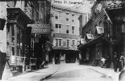
Doyers Street (in Chinatown) was called "The Bloody Angle" around 1900 because of Chinese gang wars that occurred on the street.
Photo: Library of Congress, Prints & Photographs Division, [LC-USZ62-69696]
Photo: Library of Congress, Prints & Photographs Division, [LC-USZ62-69696]
place with historical importancehistorical layer / disappeared object
Wikipedia article: http://en.wikipedia.org/wiki/Tong_(gang)
Nearby cities:
Coordinates: 40°42'51"N 73°59'52"W
- The Brooklyn Bridge 0.6 km
- Brooklyn Heights Historic District 1.4 km
- Fort Greene Historic District 2.9 km
- Governor's Island 3.4 km
- Prospect Park 4.9 km
- Green-Wood Cemetery 6.1 km
- Center of historic "New Utrecht" 11 km
- Fort Wadsworth 13 km
- Floyd Bennett Field (NOP) 14 km
- Fort Hancock Historic Core 26 km
- Two Bridges 0.4 km
- Civic Center 0.5 km
- Lower (Downtown) Manhattan 0.8 km
- TriBeCa 1 km
- Financial District 1.2 km
- Upper New York Bay 6.5 km
- Hudson County, New Jersey 6.7 km
- Manhattan 7.7 km
- Brooklyn 9 km
- Queens 13 km