Iran /
Azarbayejan-e Gharbi /
Khoy /


West Azarbaijan Province
World / Iran / Azarbayejan-e Gharbi / Khoy , 95 km from center (خوي) World / Iran / East Azarbaijan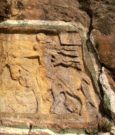
West Azarbaijan (also West Azerbaijan, Azari: Qərbi Azərbaycan, Persian:آذربایجان غربی) is one of the 30 provinces of Iran, located in the northwestern part of the country. It covers an area of 39,487 km² and has a population of 3,015,361 (2006). The capital of the province is Urmia. The name of Azerbaijan derives from Atropates, a Persian satrap of Media under the Achaemenid empire.
The climate of West Azarbaijan is largely influenced by the rainy winds of the Atlantic Ocean and Mediterranean. Cold northern winds affect the province during winter and cause heavy snow. According to existing meteorological data, local temperatures vary within the province. Average temperature differs from 9.4 °C in Piranshahr to 11.6 °C in Mahabad, while it is 9.8 °C in Urmia, 10.8 °C in Khoy. According to same data, the highest temperature in the province reaches 34 °C in July, and the lowest temperature is –16 °C in January. Maximum change of temperature in summer is 4 °C, and in winter 15 °C.
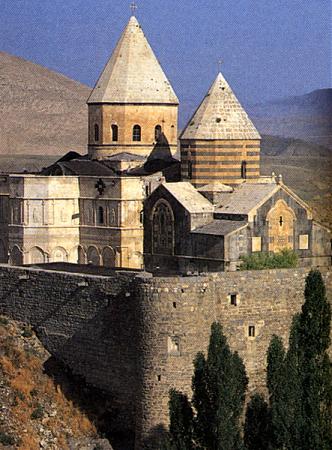
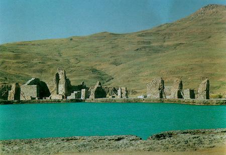
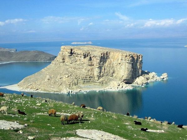
West Azarbaijan province, encompassing vast and fertile plains, high mountains, enjoying moderate and healthy weather, rivers with high volume of water, vineyards, orchards, luxuriant forest and rangelands, mountain outskirt with wonderful flora, magnificent wildlife and beautiful shores around the lake with different recreational facilities, which all together form one of the most beautiful and spectacular region in Iran. A land with wonderful flora during the spring and the summer covered with tulip, poppy, narcissus and hyacinth extending from Arass rivers banks in the north to Zab Kouchak valley in the south. Also Takht-i-Suleiman, the ruins of a fire temple from Sassanid period and a World Heritage Site, is located near Takab in West Azarbaijan.
West Azarbaijan's population are mostly Azarbaijanis and Kurds. There are three small ethnic and religious groups who are native to the province but who have minority status: Assyrians, Armenians, and Jews. There are also immigrants from other parts of Iran in the major cities of the province.
The climate of West Azarbaijan is largely influenced by the rainy winds of the Atlantic Ocean and Mediterranean. Cold northern winds affect the province during winter and cause heavy snow. According to existing meteorological data, local temperatures vary within the province. Average temperature differs from 9.4 °C in Piranshahr to 11.6 °C in Mahabad, while it is 9.8 °C in Urmia, 10.8 °C in Khoy. According to same data, the highest temperature in the province reaches 34 °C in July, and the lowest temperature is –16 °C in January. Maximum change of temperature in summer is 4 °C, and in winter 15 °C.
West Azarbaijan province, encompassing vast and fertile plains, high mountains, enjoying moderate and healthy weather, rivers with high volume of water, vineyards, orchards, luxuriant forest and rangelands, mountain outskirt with wonderful flora, magnificent wildlife and beautiful shores around the lake with different recreational facilities, which all together form one of the most beautiful and spectacular region in Iran. A land with wonderful flora during the spring and the summer covered with tulip, poppy, narcissus and hyacinth extending from Arass rivers banks in the north to Zab Kouchak valley in the south. Also Takht-i-Suleiman, the ruins of a fire temple from Sassanid period and a World Heritage Site, is located near Takab in West Azarbaijan.
West Azarbaijan's population are mostly Azarbaijanis and Kurds. There are three small ethnic and religious groups who are native to the province but who have minority status: Assyrians, Armenians, and Jews. There are also immigrants from other parts of Iran in the major cities of the province.
provincefirst-level administrative divisiondraw only border
Wikipedia article: http://en.wikipedia.org/wiki/West_Azarbaijan_Province
Nearby cities:
Coordinates: 37°52'26"N 45°41'29"E
- Northern Borders Region 956 km
- Kerman Province 1026 km
- Riyadh Province 1243 km
- Balochistan Province 1524 km
- Punjab Province 2170 km
- Mahajanga Province 5762 km
- Toliara Province 6245 km
- East Kalimantan 7795 km
- Saskatchewan 8916 km
- Papua 10030 km
- Turbine Dashy 12 km
- Tuneel 17 km
- Islamic Island 18 km
- غذاخوری 20 km
- Banafsheh island 22 km
- Ilkhchi Plain 23 km
- Lake Urmia 26 km
- Road bridge 29 km
- Urmia Lake Bridge 33 km
Comments