Naval Facility Centerville Beach (site)
USA /
California /
Ferndale /
World
/ USA
/ California
/ Ferndale
World / United States / California
military, historical layer / disappeared object, United States Navy
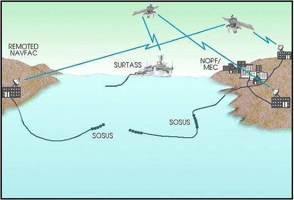
One of the many underwater listening stations that were part of the Sound Surveillance System (SOSUS) and the Integrated Undersea Surveillance System (IUSS), which were used to track Soviet submarines.
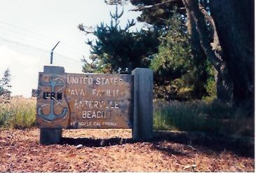
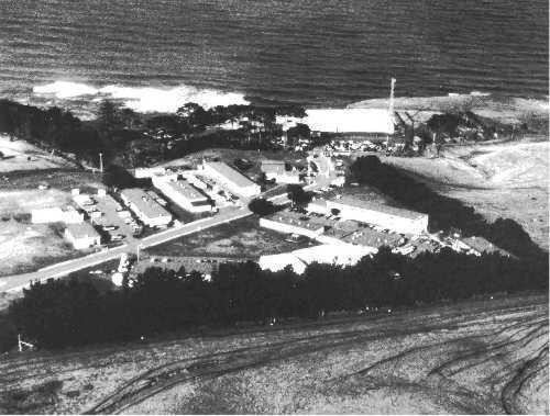
Naval Facility Centerville Beach was commissioned on 25 March 1958. From the original compliment of ninety-five personnel and sixteen buildings, it grew to 280 personnel and twenty-four major structures. The facility was located approximately 260 miles north of San Francisco and 100 miles south of the Oregon border. It was situated on thirty-seven acres of rolling pasture land on a 320 foot cliff overlooking the Eel River Valley to the North and bordered by the Pacific Ocean to the West. In addition to its operational responsibilities, NAVFAC Centerville Beach also marked the location of the Readiness Training Facility from 1978 to 1985. After weathering three earthquakes in 1992, NAVFAC Centerville Beach was re-terminated at NOPF Whidbey Island and decommissioned 30 September 1993 after nearly thirty-five years of dedicated service.
In 1992, NAVFAC Centerville Beach survived 3 earthquakes registering 6.9, 7.0, and 7.1 on the Richter scale.
www.public.navy.mil/subfor/cus/Pages/NAVFAC_Centerville...
Wikipedia article: http://en.wikipedia.org/wiki/SOSUS
Nearby cities:
Coordinates: 40°33'51"N 124°21'2"W
- FAA beacon for airplane navigation 15 km
- JSS Radar Station (J-83A, Rainbow Ridge CA) 24 km
- RV Parking Lot 26 km
- Eureka Municipal Airport and Samoa Drag Strip 28 km
- California National Guard 29 km
- USS Milwaukee memorial 30 km
- USS LCI(L)-1091 32 km
- US Coast Guard Group/Air Station Humboldt Bay 50 km
- US Coast Guard Station Noyo River 135 km
- USCG 47ft Motor Lifeboats 135 km
- Mouth of Eel River 9 km
- Bear River Band of the Rohnerville Rancheria 14 km
- Fernbridge, California 14 km
- Campton Heights 18 km
- Humboldt Hill 22 km
- Scotia, California 23 km
- Hydesville, California 23 km
- Headwaters Forest 26 km
- Humboldt Bay 28 km
- The Lost Coast 34 km
Comments