Former Eldorado Air Force Station AN/FPS-115 PAVE PAWS Radar
USA /
Texas /
Eldorado /
World
/ USA
/ Texas
/ Eldorado
World / United States / Texas
military, radar station
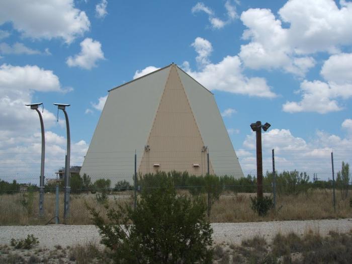
Operated by the 8th Missile Warning Squadron (later redesignated as the 8th Space Warning Squadron) from 1987 until 1995. The site was mothballed and all equipment sent to Clear AFS, AK to upgrade the former BMEWS to the new AN/FPS-120 Solid-State Phased Array Radar System (SSPARS), which became operational on 31 January 2001.
Photos of the mothballed PAVE PAWS site: www.radomes.org/museum/recent/EldoradoAFSPAVEPAWSTX.htm...
Photos of the mothballed PAVE PAWS site: www.radomes.org/museum/recent/EldoradoAFSPAVEPAWSTX.htm...
Wikipedia article: http://en.wikipedia.org/wiki/PAVE_PAWS
Nearby cities:
Coordinates: 30°58'46"N 100°33'8"W
- Camp Bowie National Guard Unit 170 km
- Camp Bullis Military Training Reservation 229 km
- Lackland Air Force Base Medina Annex 251 km
- Lackland Air Force Base and Kelly Field Annex / Port San Antonio Business Park 254 km
- Fort Cavazos 256 km
- Fort Sam Houston 260 km
- R-6312 McMullen Target Site/Range 361 km
- Joint Readiness Training Center 687 km
- Fort Johnson 698 km
- NAS/JRB New Orleans, Alvin Callender Field 1016 km
- YFZ Ranch 5.7 km
- Eldorado Airport 14 km
- Eldorado Cemetery 16 km
- Langford Wind Farm 19 km
- Noelke, Tx 40 km
- Sherwood, Texas 41 km
- 03XS Creekside Airport 42 km
- TS65 Ducote Airpark 43 km
- Midway, Tx 59 km
- Barnhart, Texas 61 km