Santa Susana Pass Stagecoach Road (Los Angeles, California)
USA /
California /
Calabasas /
Los Angeles, California
World
/ USA
/ California
/ Calabasas
World / United States / California
road, interesting place, historic landmark
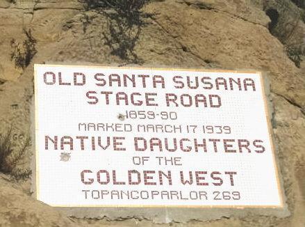
Workers began blasting sandstone to form a rudimentary road in June 1860 under the watch of James P. Thomson, a noted early Californian settler. Heavy rainfall impeded their work, and the road was not completed until 1 April 1861. The first overland mail stage coach crossed the pass five days later, completing the San Francisco to Los Angeles trip in a record 72 hours. The stage road was used until 1895, when local citizens had the "new" Santa Susana Pass Road built to the north to bypass Devil's Slide altogether.
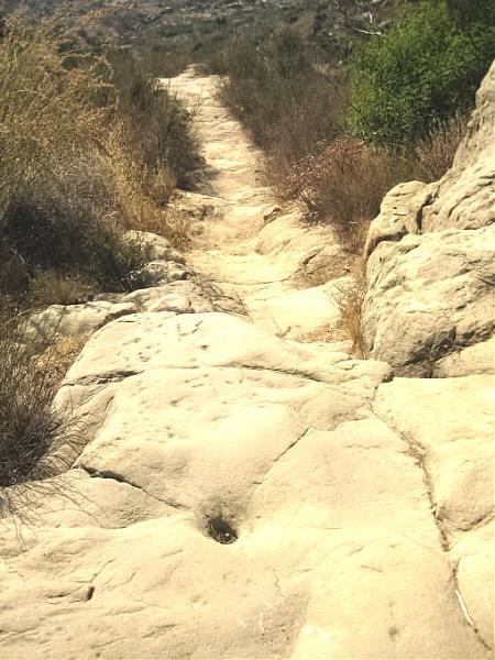
The eastern, downslope side of the pass was named The Devil's Slide. Various measures to keep the wagons from running out of control included: using a windlass to help their wagon safely descend, blindfolding their horses, using a system of steps cut into the sandstone, and augmenting the wagon's brakes with chains as using brakes alone was not enough to slow the descent. Another method used was to simply lock the rear wheels in place using chains or a wooden rod between the spokes.
www.parks.ca.gov/pages/980/files/sspshp%20historic%20re...
Wikipedia article: http://en.wikipedia.org/wiki/Old_Stagecoach_Trail
Nearby cities:
Coordinates: 34°15'38"N 118°37'42"W
- "The Snake" 24 km
- Golden State Highway, Ridge Route, Interstate 5 Highway 39 km
- Old highway 166 165 km
- Old Highway 166 170 km
- Old Highway 166 174 km
- Lower Black Mtn Road switchbacks 180 km
- Baker Grade 266 km
- the Little Dragon (hiway 49) 397 km
- Loneliest Road in America 633 km
- Old Lincoln Highway 892 km
- Chatsworth Nature Preserve and Reservoir (site) 3.2 km
- Indian Springs Open Space Park 3.4 km
- Rocky Peak Park 4.6 km
- West Hills 5.7 km
- Canoga Park 6.1 km
- Antonovich Open Space Park (Joughin Ranch Section) 6.3 km
- Porter Ranch 7 km
- Winnetka 7.4 km
- Shell Oil Fields 8.4 km
- Reseda 9 km