Mouth of the Fleet River (London)
United Kingdom /
England /
London
World
/ United Kingdom
/ England
/ London
World / United Kingdom / England
invisible, river mouth
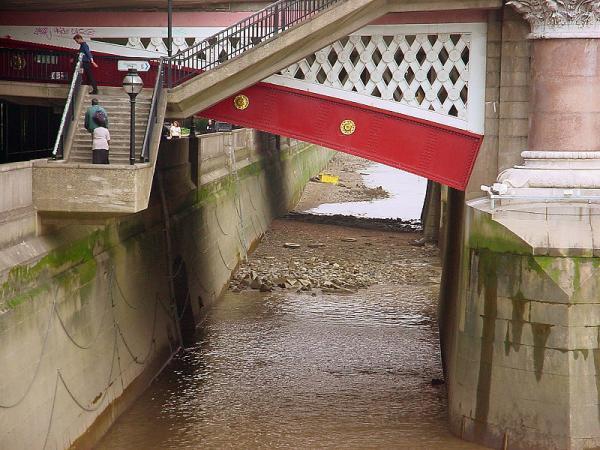
A tidal estuary until the Middle Ages, when the land was gradually reclaimed and the river narrowed. This was the outflow of an important river, formerly navigable at least as far as Holborn. It deteriorated into a notorious open sewer. For a while in the 18th century, the river mouth was embanked as a canal with warehouses, looking like part of Amsterdam. Eventually the silting, the smell and fears of disease led to the river being arched over to create the road we see today. The Fleet still flows beneath into the sewage system, acting as a storm drain. The upper parts of the river in Hampstead and Highgate are still open, forming the ponds on Hampstead Heath.
Wikipedia article: http://en.wikipedia.org/wiki/Fleet_River
Nearby cities:
Coordinates: 51°30'39"N -0°6'15"E
- Walled Perimeter of Roman Londinium 0.9 km
- Regent’s canal 3.1 km
- Deptford 4.5 km
- Central London 5.1 km
- Sydenham Hill Railway Tunnel 8.9 km
- The South Downs 102 km
- East Winner Sandbank 103 km
- Anglesey 109 km
- Thorness Bay 123 km
- The Solent 128 km
- Blackfriars Station 0.1 km
- Blackfriars Bridge 0.1 km
- Blackfriars Railway Bridge 0.2 km
- Blackfriars 0.2 km
- Baynard House 0.3 km
- Temple 0.4 km
- Inner Temple Gardens 0.4 km
- Inner and Middle Temples 0.5 km
- Holborn 1.2 km
- Camden Council 5.2 km
Comments