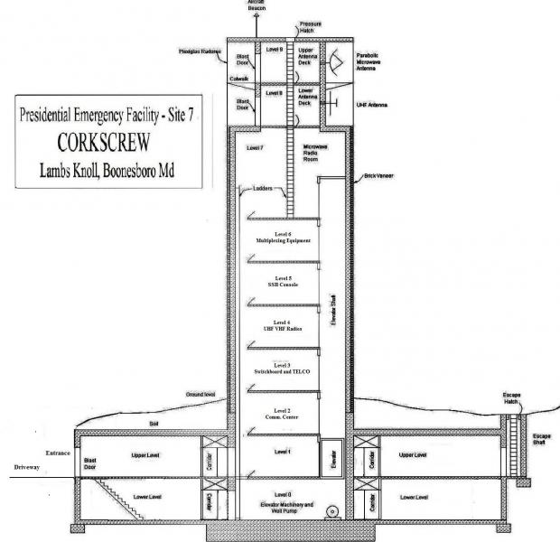
WHCA Corkscrew Facility "FAA Alternate Primary Facility"
USA /
Maryland /
Rohrersville /
World
/ USA
/ Maryland
/ Rohrersville
World / United States / Maryland
military, Cold War 1947-1991, telecommunication, microwave tower / microwave transmission, interesting place, underground station, underground facility
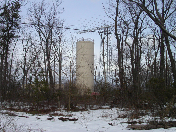
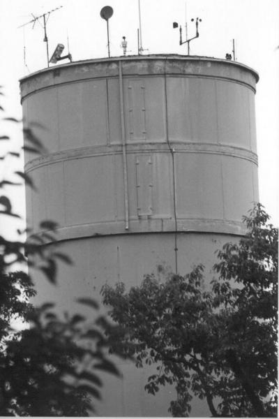
Cylindrical tower, antennae, and helipad - Obsolete Cold War artifact, now run by FAA.
Continuity of Government plans provide the capability to maintain essential government services and emergency functions in the most serious of events affecting national security. FEMA VIP Evacuation and Support Facilities in the Washington area include an installation in Boonsboro, MD.
CORKSCREW was one of several presidential emergency facilities and related communications relay stations constructed in the early 1960s in the Washington, DC region.
see others at: coldwar-c4i.net/PEF/locator.html
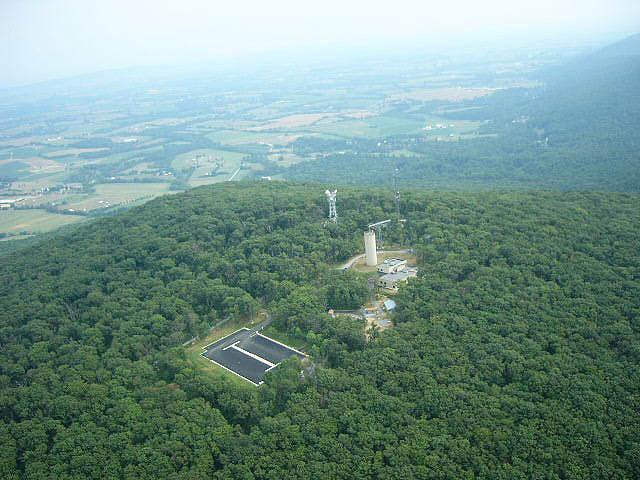
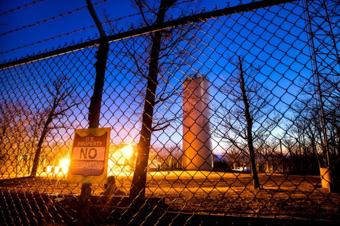
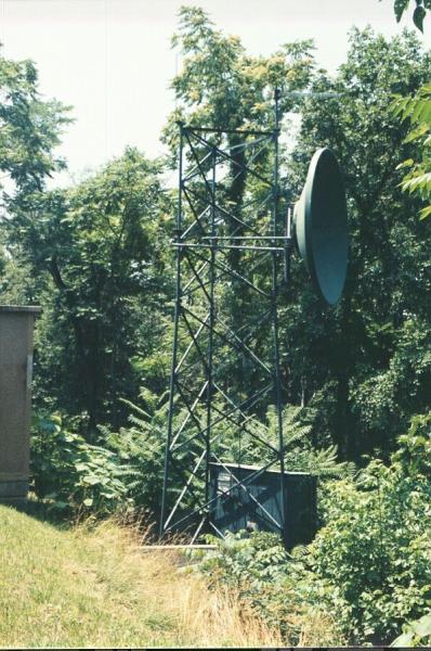
The installation is no longer in service as a presidential shelter, and is now used by the Federal Aviation Administration. The FAA has altered the exterior (and, presumably, the interior) of the facility for its purposes. These alterations include the addition of a self-supporting steel lattice tower supporting a large high-frequency (shortwave) rotatable log-periodic antenna for backup radio communications. The FAA's most recent construction project included adding and replacing several surface structures, and converting the grass helicopter landing zone into an asphalt-paved parking lot. The FAA compound is a restricted area and is protected by security personnel and systems. Visitors are not admitted unless on official business.
For at least some its operational life, the PEF shared the mountaintop with two unrelated facilities: an AT&T microwave relay station and a fire-lookout tower. The AT&T facility was made obsolete by fiber-optic cables and has been demolished. The fire tower was converted to a radio tower serving multiple Maryland state and local government agencies. That tower, which was in very poor condition, has been replaced by a modern tower and building performing the same function.
This facility, clearly visible above the trees from several major highways, is located on a mountain called Lambs Knoll. Recent annotated color close up photos at:
coldwar-c4i.net/Corkscrew/P1010661B.html
see also:
www.fas.org/nuke/guide/usa/c3i/boonsboro.htm
en.wikipedia.org/wiki/Lambs_Knoll
Continuity of Government plans provide the capability to maintain essential government services and emergency functions in the most serious of events affecting national security. FEMA VIP Evacuation and Support Facilities in the Washington area include an installation in Boonsboro, MD.
CORKSCREW was one of several presidential emergency facilities and related communications relay stations constructed in the early 1960s in the Washington, DC region.
see others at: coldwar-c4i.net/PEF/locator.html
The installation is no longer in service as a presidential shelter, and is now used by the Federal Aviation Administration. The FAA has altered the exterior (and, presumably, the interior) of the facility for its purposes. These alterations include the addition of a self-supporting steel lattice tower supporting a large high-frequency (shortwave) rotatable log-periodic antenna for backup radio communications. The FAA's most recent construction project included adding and replacing several surface structures, and converting the grass helicopter landing zone into an asphalt-paved parking lot. The FAA compound is a restricted area and is protected by security personnel and systems. Visitors are not admitted unless on official business.
For at least some its operational life, the PEF shared the mountaintop with two unrelated facilities: an AT&T microwave relay station and a fire-lookout tower. The AT&T facility was made obsolete by fiber-optic cables and has been demolished. The fire tower was converted to a radio tower serving multiple Maryland state and local government agencies. That tower, which was in very poor condition, has been replaced by a modern tower and building performing the same function.
This facility, clearly visible above the trees from several major highways, is located on a mountain called Lambs Knoll. Recent annotated color close up photos at:
coldwar-c4i.net/Corkscrew/P1010661B.html
see also:
www.fas.org/nuke/guide/usa/c3i/boonsboro.htm
en.wikipedia.org/wiki/Lambs_Knoll
Wikipedia article: http://en.wikipedia.org/wiki/Continuity_of_Operations_Plan
Nearby cities:
Coordinates: 39°26'59"N 77°37'33"W
- AT&T Long LInes Fiber Trunks from Thurmont and Camp David 26 km
- Eastern WV Regional Airport/Shepherd Field (MRB/KMRB) 33 km
- Major AT&T Long Line Cable Segment Path 62 km
- Letterkenny Army Depot 69 km
- Fort George G. Meade 81 km
- Davidsonville Transmitter Site 95 km
- Aberdeen Proving Grounds Test Track 115 km
- Aberdeen Proving Ground 118 km
- Former United States Naval Training Center, Bainbridge 132 km
- Fort Indiantown Gap Cantonment 142 km
- Lambs Knoll 0.2 km
- Rohrersville, Maryland 4.3 km
- Musket Ridge Golf Club 8.2 km
- Hollow Creek Golf Club 8.8 km
- Maryland National Golf Club 9 km
- Braddock Heights, Maryland 11 km
- Jefferson, Maryland 12 km
- Frederick County, Maryland 20 km
- Washington County, Maryland 26 km
- South Mountain 39 km