Nuclear Waste Burial Site 'Plot M'
USA /
Illinois /
Burr Ridge /
World
/ USA
/ Illinois
/ Burr Ridge
World / United States / Illinois
interesting place, nuclear waste storage
This is the surface dump site known as 'Plot M' where waste from the world's first nuclear reactor [Stagg Field CP-1 components were reassembled as CP-2 and CP-3] was deposited during WWII. This top-secret site [known now as 'Site A'] became the early Argonne National Laboratory site immediately after the war. It is perhaps the only unguarded nuclear site in the world!
Fortunately, after waste was initially simply dumped in the ravine here during WWII, dumpsters of some sort were employed, and subsequently a rather thick concrete cap was emplaced to limit rainwater infiltration into the waste and to prevent contaminated leachate migration to the surface waters or down to groundwater in the glacial till or Ordovician Dolomite bedrock.
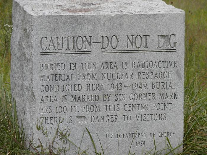
The granite monument at the site wisely encourages the public to avoid digging here due to either stupidity or presumably for more nefarious reasons. Both people and furry animals should avoid lapping up the waters in the ravines below the elevation of this site. Although I would not personally rush to devour squirrel, deer, coyote etc. southwest of Chicago in general, it seems likely that the strontium-90 or tritium levels in the surface waters and in turn in the furry animals exist below EPA limits or are absent. Of course, hunting is after all illegal in the forest preserve. The Argonne reports alert us to the fact that many natural sources of radiation such as subsurface radon and cosmic sources may provide more significant exposure to varieties of radiation.
Remnants of the worlds first nuclear reactor are located to the south at Burial 'Site A'. This is the one found in the history books [The Manhatten Project] originally constructed under the squash courts at University of Chicago. This site is not easily accessible to the public except on foot or via bicycle. I recommend ingress along the original [now gated] asphalt access road that may be found a few hundred feet south of the entrance to the Red Gate Woods. Park in the Red Gate Woods lot and traverse the occasionally muddy trails to the southwest a few hundred feet until the asphalt road is encountered or enter at your own risk adjacent to the high speed Archer Road traffic.
This hilltop became the early Argonne National Laboratory site immediately after WWII. It was reportedly chosen after a University of Chicago physicist rode his horse in these very beautiful wooded hills. They apparently were to him reminiscent of the Argonne Woods in France. In the 1950s Argonne moved to westward to the north side of the same Des Plaines River Valley through which the Louis Joliet Expedition was guided by a Native American boy in the winter of 1674 when this territory was claimed by France.
Results of monitoring are reported and available, as of 2004: www.anl.gov/Community_and_Environment/sitea2004.pdf
And the latest data:
www.anl.gov/Community_and_Environment/sitea2006.pdf
Absent in the 2004 Argonne lab documentation, is information regarding ground water flow directions and rates in the glacial till and in the underlying Ordovician Dolomite! Wupps. In my considered opinion we may at least initially hypothesize that flow in both cases may be expected to be in the direction of Archer Avenue and the IM Canal.
Thankfully the public wells at Red Gate Woods have been disabled, but one can presume that the unsuspecting public may have ingested some contaminated water prior to the 1970s.
"What err has missed our toils shall strive to mend." Jim M 2006
en.wikipedia.org/wiki/Metallurgical_Laboratory
en.wikipedia.org/wiki/Hanford_Nuclear_Reservation
Fortunately, after waste was initially simply dumped in the ravine here during WWII, dumpsters of some sort were employed, and subsequently a rather thick concrete cap was emplaced to limit rainwater infiltration into the waste and to prevent contaminated leachate migration to the surface waters or down to groundwater in the glacial till or Ordovician Dolomite bedrock.
The granite monument at the site wisely encourages the public to avoid digging here due to either stupidity or presumably for more nefarious reasons. Both people and furry animals should avoid lapping up the waters in the ravines below the elevation of this site. Although I would not personally rush to devour squirrel, deer, coyote etc. southwest of Chicago in general, it seems likely that the strontium-90 or tritium levels in the surface waters and in turn in the furry animals exist below EPA limits or are absent. Of course, hunting is after all illegal in the forest preserve. The Argonne reports alert us to the fact that many natural sources of radiation such as subsurface radon and cosmic sources may provide more significant exposure to varieties of radiation.
Remnants of the worlds first nuclear reactor are located to the south at Burial 'Site A'. This is the one found in the history books [The Manhatten Project] originally constructed under the squash courts at University of Chicago. This site is not easily accessible to the public except on foot or via bicycle. I recommend ingress along the original [now gated] asphalt access road that may be found a few hundred feet south of the entrance to the Red Gate Woods. Park in the Red Gate Woods lot and traverse the occasionally muddy trails to the southwest a few hundred feet until the asphalt road is encountered or enter at your own risk adjacent to the high speed Archer Road traffic.
This hilltop became the early Argonne National Laboratory site immediately after WWII. It was reportedly chosen after a University of Chicago physicist rode his horse in these very beautiful wooded hills. They apparently were to him reminiscent of the Argonne Woods in France. In the 1950s Argonne moved to westward to the north side of the same Des Plaines River Valley through which the Louis Joliet Expedition was guided by a Native American boy in the winter of 1674 when this territory was claimed by France.
Results of monitoring are reported and available, as of 2004: www.anl.gov/Community_and_Environment/sitea2004.pdf
And the latest data:
www.anl.gov/Community_and_Environment/sitea2006.pdf
Absent in the 2004 Argonne lab documentation, is information regarding ground water flow directions and rates in the glacial till and in the underlying Ordovician Dolomite! Wupps. In my considered opinion we may at least initially hypothesize that flow in both cases may be expected to be in the direction of Archer Avenue and the IM Canal.
Thankfully the public wells at Red Gate Woods have been disabled, but one can presume that the unsuspecting public may have ingested some contaminated water prior to the 1970s.
"What err has missed our toils shall strive to mend." Jim M 2006
en.wikipedia.org/wiki/Metallurgical_Laboratory
en.wikipedia.org/wiki/Hanford_Nuclear_Reservation
Wikipedia article: http://en.wikipedia.org/wiki/Site_A/Plot_M_Disposal_Site
Nearby cities:
Coordinates: 41°42'25"N 87°54'38"W
- Former Site of the Union Stock Yards 24 km
- South fork of the south branch of the Chicago River 25 km
- Homewood Izaak Walton Park 26 km
- Chicago, Illinois 35 km
- I.U.O.E. ASIP Local 150 (Training Center) 43 km
- Marquette Park 54 km
- Meeting point of Indiana, Illinois, and Michigan state boundaries 58 km
- Lake Greenfield 66 km
- Sun Aura Resort 79 km
- Fair Oaks Farms 86 km
- Red Gate Woods 0.4 km
- Des Plaines Riverway Forest Preserve 1.1 km
- Maple Lake West 1.8 km
- Edgewood Valley Country Club 5.4 km
- Argonne National Laboratory 5.5 km
- Waterfall Glen Forest Preserve 5.5 km
- Area 300 5.6 km
- Harvester Park 5.9 km
- Area 200 6 km
- DuPage County, Illinois 21 km