The 'M'
USA /
Montana /
Missoula /
World
/ USA
/ Montana
/ Missoula
World / United States / Montana
hillside letter
Add category
The 'M' - University of Montana
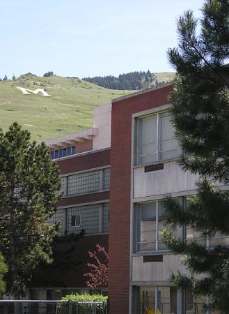
The "M" is the west face of Mount Sentinel at an altitude of 3,200 ft. It has been a landmark for the university and the city since 1908, when Forestry Club members forged a zigzag trail up the mountain and students carried up stones to shape the symbol of the University of Montana. Since 1968 the "M" has been made of concrete.
Hiking to the "M" is a favorite Missoula outing. As you ascend, the view expands to include all of Missoula, the valley, the Clark Fork River and distant mountains. Eleven switchbacks zigzag for a gain of 620 feet from the trail head to the "M."
Nearby cities:
Coordinates: 46°51'33"N 113°58'32"W
- 50 274 km
- Kenmare High School grad markers 916 km
- Bismarck in Trees 1008 km
- "E" 1180 km
- Box Springs Mountain 1463 km
- "A" Mountain in Ajo 1616 km
- Kody Dwire 2898 km
- The Letters "AF" 3411 km
- Huge text on ground. Glory to the Soviet border guards! 4008 km
- Fovant Regimental Badges 7348 km
- East Missoula, Montana 3.4 km
- Pine Grove 7 km
- Bonner - West Riverside, Montana 7 km
- Missoula International Airport (MSO/KMSO) 11 km
- Lolo, Montana 14 km
- Wye, Montana 17 km
- Montana Snowbowl 19 km
- Florence, Montana 26 km
- Frenchtown, Montana 27 km
- Lee Metcalf National Wildlife Refuge 34 km