Rampal Upazila HQ
Bangladesh /
Bagar Hat /
World
/ Bangladesh
/ Bagar Hat
/ Bagar Hat
World / Bangladesh / Barisal / Patuakhali / Borgona
township, subdistrict, fourth-level administrative division, local government
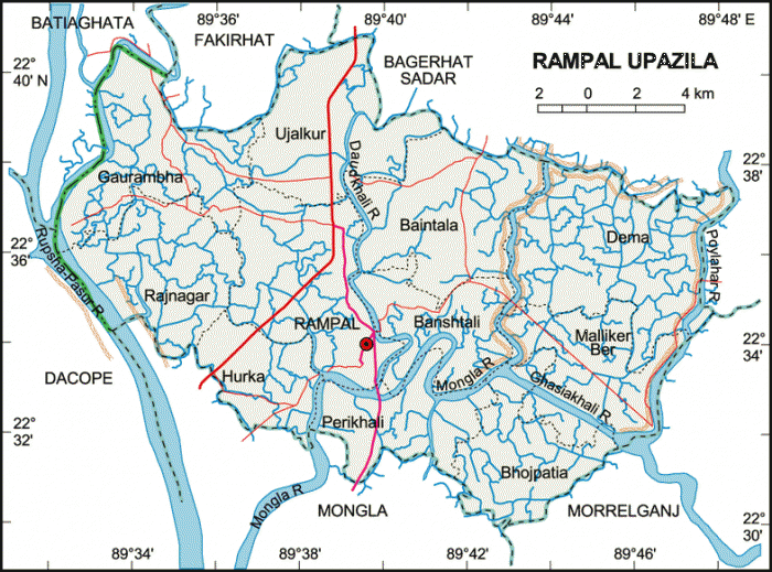
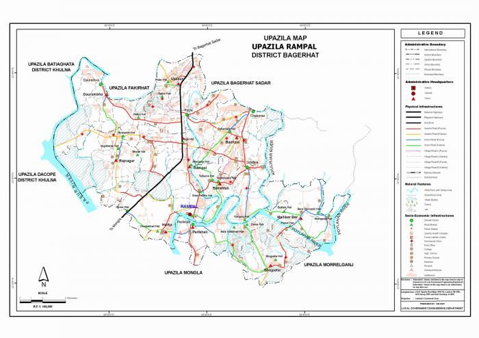
Rampal Upazila (Bagerhat district) with an area of 335.46 sq km, is bounded by Bagerhat sadar and Fakirhat upazilas on the north, Mongla and Morrelganj upazilas on the south, Morrelganj and Bagerhat Sadar upazilas on the east, Batiaghata and Dacope upazilas on the west. Main rivers are Mongla, Rupsa, Khashikhali and Daudkhali.
The location of the Rampal town is 22.5552905N 89.6508515E. Rampal (Town) consists of one mouza. The area of the town is 0.92 sq km. It has a population of 1485; male 59.73, female 40.27%. The literacy rate among the town people is 77.5%. The town has one dakbungalow.
Rampal thana was established in 1892 and was turned into an upazila in 1983. It consists of 11 union parishads, 131 mouzas, 149 village.
Religious institutions: Mosque 204, temple 68 and church 2, most noted of which is Rampal Jami Mosque.
As of the 1991 Bangladesh census: Population 167070; male 50.83% and female 49.17%; Muslim 75.31%, Hindu 24.42%, others 0.27%.
Literacy and educational institutions: Average literacy 45.5%; male 51.5%, female 39.2%. Educational institutions: college 3, high school 27, government primary school 67, junior school 16, non-government primary school 46 and madrasa 88. Noted old institution is Gilatala Multilateral High School (1929).
Cultural organisations: Public library 1, shilpakala academy 1, community hall 4 and rural club 26.
Main occupations: Agriculture 33.52%, fishing 3.63%, sericulture 1.79%, agricultural labourer 20.13%, wage labourer 6.92%, commerce 13.97%, transport 1.34%, service 4.87%, others 13.83%.
Land use: Arable land 20857.95 hectare and fallow land 4.04 hectares; single crop 43.26%, double crop 36.24% and treble crop land 20.50%.
Fisheries, dairies and poultries Fishery 913 (shrimp cultivation), poultry 66 and dairy 4, artificial breeding centre 1.
Communication facilities- Roads: pucca 30 km, semi pucca 19 km and mud road 378.
Cottage industries: Weaving 23, wood work 206, blacksmith 30, goldsmith 20 and tailoring 178.
NGO activities: Operationally important NGOs are asa, brac, caritas.
Health centres: Upazila health complex 1, satellite clinic 1 and family planning centre 10.
Nearby cities:
Coordinates: 22°34'27"N 89°39'38"E
- Kachua Upazila HQ 23 km
- Fakirhat Upazila HQ 26 km
- Koyra Upzila HQ 46 km
- Abhaynagar Upazila HQ 62 km
- Sarishabari Upazila 252 km
- Shaghatta Upazila 298 km
- Gobindaganj Upazila 300 km
- Bholahat Upazila HQ 305 km
- Maidi Vdc 774 km
- Samote Union Council 1994 km
- Sadar upazila to sundarban union road, Bagerhat 8.5 km
- Sundarban Unon, Mongla Upazila 10 km
- Bhorbunia Union, Morrelganj Upazila 15 km
- Nishanbaria Union, Morrelganj Upazila 19 km
- sangdia 21 km
- Zianagar Upazila 32 km
- Pirojpur District Town 33 km
- Khulna Division 50 km
- Barishal Division 73 km
- Sundarbans 81 km
Comments