Hòn Ngư (Hon Ngu)
Vietnam /
Khu Bon Cu /
Vinh /
World
/ Vietnam
/ Khu Bon Cu
/ Vinh
World / Vietnam / Bắc Trung Bộ / Hà Tĩnh / Cẩm Xuyên
island, interesting place

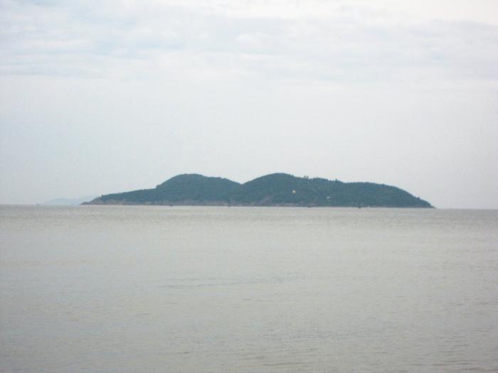
The island is 4 km offshore. It consists of 2 islands: the larger stands at 133 m above sea level and the smaller at 88 m. Phan Huy Chu wrote in the book "Lich trieu hien chuong loai chi": the twin mountains at Hoi Thong estuary ... look like two fish, thus are called Song Ngu (two fish) mountain. The locals therefore call the island Dao Ngu hay Hon Ngu (Fish island). The best place to grasp the whole landscape of Hon Ngu is from the river mouth. Cua Lo river starts off from the west, past Huong Van, Phan Thanh. Part of the river flows into Nha Le Canal and the rest of it cuts across Thien Ly road, now known as 1A Highway, at the Cau Cam bridge, then flows between Dau Voi and Ru Cam shrubby woodlands. Before flowing into the sea, the river meets the Ru Dung forest and Lang Kho forest on the north side, turning south out to sea. People say that moutains and rivers give landscapes their beauty, but here there are not just mountains and rivers, but also blue sea. Due to the position of Hon Ngu, Cua Lo beach is very scenic and beautiful. The blue of the sea water all year round is mixed with the white clouds and light red in the horizon on clear mornings. That natural beauty could even beat the blues out of lonely souls. The island gives great protection to fishermen's small boats. Bai Chua is located to the west of Hon Ngu. The pagoda was built during the 13th century includes a pagoda and a garden. The pagoda includes chua Thuong (upper) and chua Ha (lower), each pagoda has 3 sections. The supporting timbers are carved with the four religious animals (Dragon, Tiger, Unicorn, Phoenix). The garden has many natural green trees: Dai (frangipani), Mung, Duoi (there are two one-hundred-year old trees) and one fresh water well called Gieng Ngoc. Apart from swimming by the beach, enjoying the scenic landscape and fresh air, tourists can also entertain themselves with hiking, going on boat trips around the island, visiting the fishfarm Ca Do Dao Ngu. The island has become an attractive tourist stop for all holiday makers to Cua Lo "the must-see place once you are at Cua Lo beach".
Nearby cities:
Coordinates: 18°48'4"N 105°46'32"E
- ĐẢO HÒN MÊ - VN 66 km
- Rừng Thông 146 km
- Cồn Lu 180 km
- Sand island. 185 km
- Vanh River Islet 185 km
- island+sand 193 km
- Ha Nam 259 km
- Island 349 km
- Thac Ba island 359 km
- island 456 km
- Cua Hoi beach 3.9 km
- Cửa Lò Beach 4.3 km
- Nghi Hai secondary school 4.6 km
- Cua Lo Golf 4.6 km
- Xuan Hoi commune 5.6 km
- Xuan Hoi preschool 7 km
- Xuan Truong commune 8.1 km
- Phuc Tho commune 10 km
- Huyện Nghi Xuân - Hà Tĩnh 17 km
- Nghi Loc district 18 km
Comments