USA /
District of Columbia /
Washington /
Washington, D.C.

Closed section of Pennsylvania Avenue (Washington, D.C.)
World / USA / District of Columbia / Washington World / United States / District of Columbia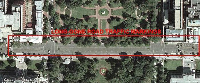
This portion of Pennsylvania Avenue was closed to vehicular traffic after the Oklahoma City bombings and never reopened. After the September Eleventh attacks ushered in the "New Security" era in the USA, aerial photos of this area were censored. In a recent compromise, overhead photography has been re-allowed, but only if old. Thus, until 2010 even though the traffic markings and blacktop pavement surface had been gone for years, map websites continued to show this "time machine" view into the street's past life (see photo, circa 2009). For a decade, the actual surface resembled a cobblestone or brick street made of tightly-packed pedestrian walkway paver-stones ---no traffic marking paint despite almost a decade of double-yellow line being visible on some map-servers. Late 2010 GoogleMaps views show the paver-stones.
road
Add category
Nearby cities:
Coordinates: 38°53'55"N 77°2'11"W
- DC "Pentagram" 1.6 km
- Free walking route to Great Falls 22 km
- VA 28 (Sully Road)/VA 662 (Westfields Blvd.) Interchange 36 km
- West Baltimore Brick Paved Streets 55 km
- Abandoned Eaglehead Drive 63 km
- Former alignment of PA Route 53 (Pre-1960) 221 km
- Pancoastal Highway 250 km
- Snug Harbor Rd 312 km
- Alley Pond Environmental Center (APEC) 349 km
- Nassau Boulevard(Former NY 25D) 351 km
- President's Park 0.3 km
- Downtown 0.5 km
- Golden Triangle 0.7 km
- George Washington University 0.9 km
- Foggy Bottom 1.1 km
- Constitution Gardens 1.1 km
- The National Mall 1.4 km
- West Potomac Park 1.5 km
- Rock Creek Park 5.2 km
- Arlington County, Virginia 6 km
Comments