Bldg 108, AN/MPS-14 Height-Finder Radar
USA /
California /
Lexington Hills /
World
/ USA
/ California
/ Lexington Hills
World / United States / California
military, radar station, historical layer / disappeared object
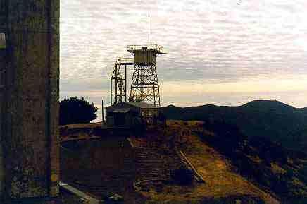
DEMOLISHED - November, 2013
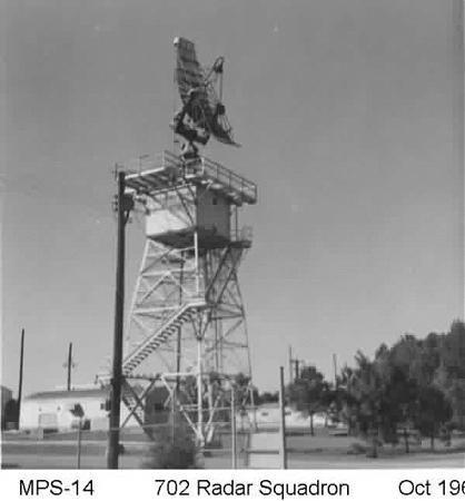
Provided altitude information on incoming targets. Used to round out the data acquired by the nearby AN/FSP-24. The antenna photo is to show what Almaden's MPS-14 would have looked like in operation.
Provided altitude information on incoming targets. Used to round out the data acquired by the nearby AN/FSP-24. The antenna photo is to show what Almaden's MPS-14 would have looked like in operation.
Wikipedia article: http://en.wikipedia.org/wiki/Height_finder
Nearby cities:
Coordinates: 37°9'36"N 121°53'49"W
- Lockheed Martin Space Systems, Santa Cruz Facility 29 km
- Castroville Amphibious Training Area (site) 46 km
- Fort Ord Housing 58 km
- Bombing Target No. 5 (site) 59 km
- Presidio of Monterey and Defence Language Institute Foreign Language Center (DLI-FLC) 61 km
- California National Guard Training Area 61 km
- Camp Shoemaker 63 km
- Gustine Bombing Range (site) 71 km
- Naval Auxiliary Air Station, Vernalis 71 km
- Tracy Defense Distribution Depot 77 km
- Mount Umunhum/Almaden Air Force Station 0.5 km
- Sierra Azul Open Space Preserve 1.6 km
- Lake Elsman 4.1 km
- Almaden Quicksilver County Park 4.4 km
- Mountain Charlie Christmas Tree Farm 8.3 km
- Soquel Demonstration State Forest 8.9 km
- Alfred Hitchcock Estate 11 km
- Uvas Canyon County Park 13 km
- The Forest of Nisene Marks State Park 15 km
- San Andreas Fault Zone 30 km