USA /
California /
San Francisco /
San Francisco, California


Fort Winfield Scott (San Francisco, California)
World / USA / California / San Francisco World / United States / California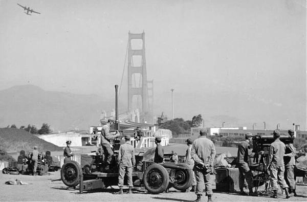
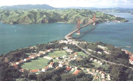
Although pinning down Ft. Scott's precise boundaries is difficult due to the fort's fluid nature of existence throughout its history, the polygon outline shows a rough boundary according to a 1920 map of the fort.
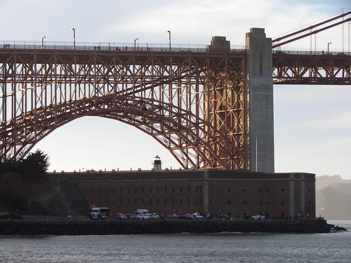
A source of confusion in any discussion of the military posts of San Francisco Bay is Fort Winfield Scott. Defining exactly what and where it was is no simple matter, and there were two phases to the use of the term, but for the purpose of understanding what it meant there are two central facts: Fort Winfield Scott was physically a part of what is generally understood as the Presidio of San Francisco; and since 1910 it has comprised in part a geographically separate and architecturally distinct set of buildings around a separate parade ground most of them built in 1910, 1921 and 1912. The layout of the buildings was in the form of a hook or backwards "J" with the top of the letter to the north.
The earliest usage of the name was somewhat different. The masonry and brick fort built in the 1850s on the site of the old Spanish Castillo de San Joaquin did not, for more than twenty years after acquiring its first garrison in 1861, have a formal military name. The point of land on which it was built had been called by the Americans "Fort Point" because of the location there of the old Spanish castillo and, subsequently, the American fort which replaced it. But that was not the official name of the fort. It was referred to in official Army documents as "the fort at Fort Point," but of course in common usage, the term "Fort Point" more often referred to the fortification itself than the point of land on which it stood.
Then on November 25, 1882, Headquarters of the Army issued General Orders No. 133 which officially named that fort at Fort Point, "Fort Winfield Scott," after the general who was a hero of the Mexican War and who commanded the Union Army at the beginning of the Civil War. However, only four years later, the fort was downgraded to being a mere sub-post of the Presidio of San Francisco with its name discontinued on September 15, 1886. In common usage, of course, the name survived for many years more, although it had no administrative meaning.
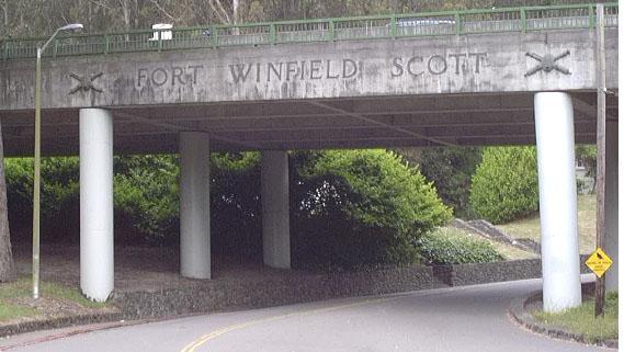
Planning had been in progress in the 1890s as new types of breechloading long range guns were being emplaced around San Francisco Harbor for a garrison for the men to man those which were within the Presidio as well as a coast defense headquarters distinct from the Presidio. But this was not actually constructed until 1909-1912, and when was finished the old name was resurrected. On June 18, 1912, in response to instructions issued from the War Department in Washington on February 16, the Western Division published General Orders No. 11 which stated that "Fort Winfield Scott, California, is established as an independent coast artillery post, to take effect at 12 o'clock noon., June 19, 1912, and the headquarters of the Artillery District of San Francisco will be located thereat." Thus Fort Winfield Scott was a coast artillery garrison which comprised roughly the northwestern quarter of the land in the boundaries of the Presidio of San Francisco, and had responsibility for all the seacoast defense batteries, torpedo or mine facilities, and other supporting structures elsewhere in the Presidio, but principally along its northern and western edges. Defining the actual boundary of Fort Winfield Scott is virtually impossible as it seems never to have been consistently specified. The one and only true "entrance" to Fort Winfield Scott consists of lettering spelling out that name, flanked by the crossed-cannon-with-shell insignia of the Coast Artillery Corps, which are on the east side of the Highway 1 overpass over Kobbe Avenue.
Read more here: www.militarymuseum.org/FtScott.html
A source of confusion in any discussion of the military posts of San Francisco Bay is Fort Winfield Scott. Defining exactly what and where it was is no simple matter, and there were two phases to the use of the term, but for the purpose of understanding what it meant there are two central facts: Fort Winfield Scott was physically a part of what is generally understood as the Presidio of San Francisco; and since 1910 it has comprised in part a geographically separate and architecturally distinct set of buildings around a separate parade ground most of them built in 1910, 1921 and 1912. The layout of the buildings was in the form of a hook or backwards "J" with the top of the letter to the north.
The earliest usage of the name was somewhat different. The masonry and brick fort built in the 1850s on the site of the old Spanish Castillo de San Joaquin did not, for more than twenty years after acquiring its first garrison in 1861, have a formal military name. The point of land on which it was built had been called by the Americans "Fort Point" because of the location there of the old Spanish castillo and, subsequently, the American fort which replaced it. But that was not the official name of the fort. It was referred to in official Army documents as "the fort at Fort Point," but of course in common usage, the term "Fort Point" more often referred to the fortification itself than the point of land on which it stood.
Then on November 25, 1882, Headquarters of the Army issued General Orders No. 133 which officially named that fort at Fort Point, "Fort Winfield Scott," after the general who was a hero of the Mexican War and who commanded the Union Army at the beginning of the Civil War. However, only four years later, the fort was downgraded to being a mere sub-post of the Presidio of San Francisco with its name discontinued on September 15, 1886. In common usage, of course, the name survived for many years more, although it had no administrative meaning.
Planning had been in progress in the 1890s as new types of breechloading long range guns were being emplaced around San Francisco Harbor for a garrison for the men to man those which were within the Presidio as well as a coast defense headquarters distinct from the Presidio. But this was not actually constructed until 1909-1912, and when was finished the old name was resurrected. On June 18, 1912, in response to instructions issued from the War Department in Washington on February 16, the Western Division published General Orders No. 11 which stated that "Fort Winfield Scott, California, is established as an independent coast artillery post, to take effect at 12 o'clock noon., June 19, 1912, and the headquarters of the Artillery District of San Francisco will be located thereat." Thus Fort Winfield Scott was a coast artillery garrison which comprised roughly the northwestern quarter of the land in the boundaries of the Presidio of San Francisco, and had responsibility for all the seacoast defense batteries, torpedo or mine facilities, and other supporting structures elsewhere in the Presidio, but principally along its northern and western edges. Defining the actual boundary of Fort Winfield Scott is virtually impossible as it seems never to have been consistently specified. The one and only true "entrance" to Fort Winfield Scott consists of lettering spelling out that name, flanked by the crossed-cannon-with-shell insignia of the Coast Artillery Corps, which are on the east side of the Highway 1 overpass over Kobbe Avenue.
Read more here: www.militarymuseum.org/FtScott.html
place with historical importancefortificationinteresting placedraw only borderclosed / former military
Wikipedia article: http://en.wikipedia.org/wiki/Presidio_of_San_Francisco
Nearby cities:
Coordinates: 37°48'2"N 122°28'21"W
- The Presidio of San Francisco 1.7 km
- Fort Barry 7.1 km
- Fort Ord (site) 135 km
- Fort Irwin NTC Main Post Area 587 km
- Weapons Storage Bunkers 988 km
- Fort Carson 1531 km
- Schriever Air Force Base 1568 km
- Pinon Canyon Maneuver Site 1605 km
- Fort Leavenworth 2392 km
- Fort Polk (cantonment) 2776 km
- San Francisco National Cemetery 0.7 km
- Crissy Field 0.8 km
- Presidio Golf Course 1.1 km
- Mountain Lake Park 1.4 km
- East Beach 1.4 km
- Crissy Field Tidal Marsh 1.5 km
- Crissy Field 1.7 km
- Inner Richmond 2.2 km
- Presidio Heights 2.2 km
- San Francisco Bay 19 km