Avalon Canyon (Daisaku Ikeda Canyon) (Daly City, California)
USA /
California /
Broadmoor /
Daly City, California
World
/ USA
/ California
/ Broadmoor
canyon / gorge, landslide

The canyon is part of the Golden Gate National Recreation Area, making it a part of the National Park System. As such, it is a no-fly zone for UAV's and other small aircraft.
In 2000, Daly City implemented a major re-grading project for the canyon and installed a new 28-inch diameter storm drain to convey storm water runoff from Skyline Drive to an outfall on the beach at the base of Avalon Canyon.
Pedestrian public access at Avalon Canyon was formally established by the City in 2001 by means of a
City-improved access road beginning from Avalon Drive sidewalk and continuing in switchbacks to an
existing outfall just above the beach below. The road was constructed as a means to allow for
maintenance of City storm facilities located in the canyon.
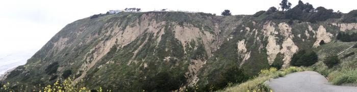
Another major landslide occurred at Avalon Canyon in December 2003 and an extensive geologic study of the conditions indicated that the new landslide could grow and undermine a portion of the Canyon Access Road constructed in 2000 and the 28-inch diameter storm drain.
Since the City granted public access to Avalon Canyon, the geology of the canyon has become
increasingly unstable. In December 2003, the steep coastal bluff immediately west of Northridge Drive
experienced a massive landslide involving approximately 860,000 tons of soil and rock debris. The
landslide resulted in the potential for even more landslides in the area extending from the shoreline
upslope to the crest of the bluff at an elevation of approximately 500 feet.
In a 2004 study concerning the landslide, geologists concluded that the landslide area remained one of
extremely high risk to personal injury and recommended that the certain areas in the vicinity of the
landslide be cordoned off with protective fencing to prevent people from gaining access to this high
risk area. In consideration of this recommendation the City closed access to the canyon in 2004.
In 2000, Daly City implemented a major re-grading project for the canyon and installed a new 28-inch diameter storm drain to convey storm water runoff from Skyline Drive to an outfall on the beach at the base of Avalon Canyon.
Pedestrian public access at Avalon Canyon was formally established by the City in 2001 by means of a
City-improved access road beginning from Avalon Drive sidewalk and continuing in switchbacks to an
existing outfall just above the beach below. The road was constructed as a means to allow for
maintenance of City storm facilities located in the canyon.
Another major landslide occurred at Avalon Canyon in December 2003 and an extensive geologic study of the conditions indicated that the new landslide could grow and undermine a portion of the Canyon Access Road constructed in 2000 and the 28-inch diameter storm drain.
Since the City granted public access to Avalon Canyon, the geology of the canyon has become
increasingly unstable. In December 2003, the steep coastal bluff immediately west of Northridge Drive
experienced a massive landslide involving approximately 860,000 tons of soil and rock debris. The
landslide resulted in the potential for even more landslides in the area extending from the shoreline
upslope to the crest of the bluff at an elevation of approximately 500 feet.
In a 2004 study concerning the landslide, geologists concluded that the landslide area remained one of
extremely high risk to personal injury and recommended that the certain areas in the vicinity of the
landslide be cordoned off with protective fencing to prevent people from gaining access to this high
risk area. In consideration of this recommendation the City closed access to the canyon in 2004.
Nearby cities:
Coordinates: 37°40'57"N 122°29'37"W
- Grand Canyon National Park 764 km
- The Grand Canyon (western section) 770 km
- The Grand Canyon (west-central section) 850 km
- Columbia River Gorge National Scenic Area 904 km
- The Grand Canyon (central section) 911 km
- The Grand Canyon (north-east section) 935 km
- Little Colorado River Gorge 969 km
- Monument Valley Navajo Tribal Park 1090 km
- Carrizo Creek Canyon 1132 km
- Carcajou canyon 3053 km
- Skyline Plaza 0.5 km
- Westmoor High School 1 km
- Mussel Rock Park 1.6 km
- Daniel Webster Elementary School 1.6 km
- Traditions Belhaven 1.8 km
- Fairmont Shopping Center 2.8 km
- Sunset Ridge School 3.5 km
- Manor Beach 3.6 km
- San Bruno faults - Daly City 4.9 km
- San Andreas Fault Zone 108 km