Thompson Peak Look Out/Janesville Gap Filler Annex SM-157A (site)
USA /
California /
Susanville /
Thompson Peak Road
World
/ USA
/ California
/ Susanville
World / United States / California
fire station, scenic lookout, radar station, interesting place

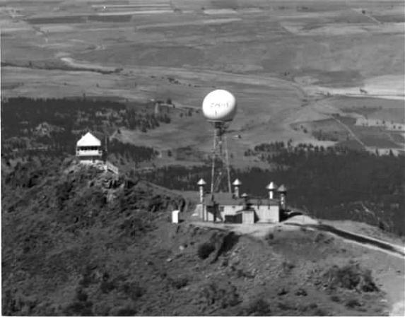
Gap filler radar was used to fill in the gaps between the footprints of long range radar. This particular GFA was active between June 1960 and December 1967. The L-shaped building is the original building built by the Air Force. It consists of two rooms: the equipment room which once contained the transmitter and receiver, and the generator room which supplied the juice for the whole operation. Although this was an unmanned site, as gap filler annexes usually are, military personnel would have come here to perform regular maintenance and fix equipment as necessary. The site is now used by the Forest Service as a fire lookout.
"On 21 July 1958, the U.S. Government acquired 37.12 public domain (pd.) acres and on 5 August 1958, they acquired 0.30 p.d. acres from the United States Department of Agriculture, Forest Service (USDA-USFS). Total acreage acquired for the subject site was 37.42.
"The site, located in Plumas County, 13 miles southwest of Susanville, California, was known as Janesville Gap Filler Annex (Z-157A), also known as Janesville Gap Filler Annex (SM-157A), Gap Filler Radar Site SM-1574 Thompson Peak Mountain, and Janesville Gap Filler Annex (Z157A)LTMJ, CA. The property was used by the Air Defense Command as an unmanned radar gap filler station. Improvements to the site consisted of one concrete block equipment and generator building, two 15,000-gallon fuel storage tanks, a 70-foot high steel antenna tower, a woven wire fence, and a gravel surfaced road.
"On 28 March 1969, 37.42 public domain acres were re-transferred to USDF."
This site used an AN/FPS-18 radar antenna:
"This medium-range search radar was designed and built by Bendix as a SAGE system gap-filler to provide low-altitude coverage. The radar operated in the S-band at a frequency between 2700 and 2900 MHz. The system deployed in the late 1950s and 1960s."
www.radomes.org/museum/equip/radarequip.php?link=fps-18...
Wikipedia article: http://en.wikipedia.org/wiki/Semi_Automatic_Ground_Environment
Nearby cities:
Coordinates: 40°15'39"N 120°33'26"W
- Barrel Springs Back Country Byway (portion crossing the CA & NV border) 187 km
- Pistol River State Scenic Viewpoint 393 km
- Fuji Mountain 400 km
- Tidbits Mountain 470 km
- Mecca Hills Wilderness Area (BLM) 834 km
- Orocopia Mountains Wilderness Area (BLM) 843 km
- Knox Mountain 1079 km
- Chockie Mountain Bypass 2252 km
- Pedernales Falls 2297 km
- Makapu'u 4085 km
- Honey Lake 21 km
- Mountain Meadow Reservoir 35 km
- Sierra Army Depot 37 km
- Military Explosives Storage 38 km
- Eagle Lake 45 km
- Former Frenchman Creek Camp (site) 47 km
- Grasshopper Valley Lake 63 km
- Smoke Creek Desert 84 km
- Sutcliffe, Nevada 86 km
- Pyramid Lake 89 km