USA /
District of Columbia /
Washington /
Washington, D.C.


Meridian Hill Park (Washington, D.C.)
World / USA / District of Columbia / Washington World / United States / District of Columbia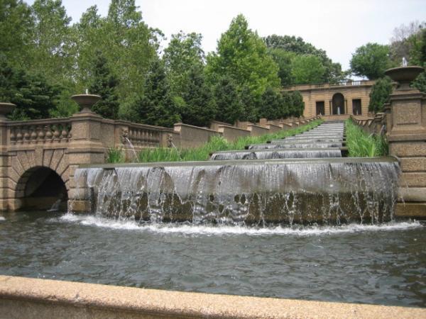

Also known as Malcolm X Park.
The park has had a long and varied history. In 1819, John Porter erected a mansion on the grounds across 16th Street. It was to this mansion that John Quincy Adams moved when he left the White House in 1829. The mansion was named "Meridian Hill" because it was on the exact longitude of the original District of Columbia milestone marker, set down on April 15, 1791 (see Jones Point, Virginia) by Major Andrew Ellicott assisted by Benjamin Banneker, an African-American astronomer and mathematician.
This meridian, originally intended to be an alternative to the Greenwich Meridian, is also adjacent to 16th Street, whose north-south axis intersects the Jefferson Memorial and White House.
At that time, the entire high ground surrounding the park was known as "Meridian Hill."
Florida Avenue, the narrow, irregular street on the south side, runs along the edge of a geological formation known as the Fall Line.
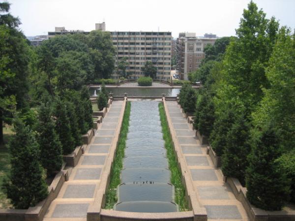
This escarpment divides the flat Atlantic Coastal Plain from the lush, hilly Piedmont area. As a result, from the middle of the park one can see over many of the surrounding buildings for a view of downtown D.C. (See also Cardozo High School nearby for an even better view.)
When the park was created, a formal lawn was installed at the north end which resembles a miniature version of the Mall. This lawn is now a popular spot for soccer games, political rallies, and drum circles. The Lawn projects up to 5-10 stories above surrounding terrain, supported by decorative concrete retaining walls with covered staircases. On the south end, a formal Renaissance fountain/staircase extends down to Florida Avenue.
The park was formally renamed Malcolm X Park by the District of Columbia, however the National Park Service did not recognize the change. Formerly known as a dangerous haven for drug dealers because of the high walls, the park is now considered an attractive place for families and soccer matches due to large-scale immigration and major renovation efforts to the park and surrounding buildings.
Meridian Hill Park, situated along 16th Street, marks the dividing line between Adams-Morgan to the west and Columbia Heights/U Street-Cardozo to the east. The park is listed on the National Register of Historic Places (NRHP), where it is designated a U.S. National Historic Landmark District. Several New Deal depression relief agencies were involved in the final years of development of the park.
The park has had a long and varied history. In 1819, John Porter erected a mansion on the grounds across 16th Street. It was to this mansion that John Quincy Adams moved when he left the White House in 1829. The mansion was named "Meridian Hill" because it was on the exact longitude of the original District of Columbia milestone marker, set down on April 15, 1791 (see Jones Point, Virginia) by Major Andrew Ellicott assisted by Benjamin Banneker, an African-American astronomer and mathematician.
This meridian, originally intended to be an alternative to the Greenwich Meridian, is also adjacent to 16th Street, whose north-south axis intersects the Jefferson Memorial and White House.
At that time, the entire high ground surrounding the park was known as "Meridian Hill."
Florida Avenue, the narrow, irregular street on the south side, runs along the edge of a geological formation known as the Fall Line.
This escarpment divides the flat Atlantic Coastal Plain from the lush, hilly Piedmont area. As a result, from the middle of the park one can see over many of the surrounding buildings for a view of downtown D.C. (See also Cardozo High School nearby for an even better view.)
When the park was created, a formal lawn was installed at the north end which resembles a miniature version of the Mall. This lawn is now a popular spot for soccer games, political rallies, and drum circles. The Lawn projects up to 5-10 stories above surrounding terrain, supported by decorative concrete retaining walls with covered staircases. On the south end, a formal Renaissance fountain/staircase extends down to Florida Avenue.
The park was formally renamed Malcolm X Park by the District of Columbia, however the National Park Service did not recognize the change. Formerly known as a dangerous haven for drug dealers because of the high walls, the park is now considered an attractive place for families and soccer matches due to large-scale immigration and major renovation efforts to the park and surrounding buildings.
Meridian Hill Park, situated along 16th Street, marks the dividing line between Adams-Morgan to the west and Columbia Heights/U Street-Cardozo to the east. The park is listed on the National Register of Historic Places (NRHP), where it is designated a U.S. National Historic Landmark District. Several New Deal depression relief agencies were involved in the final years of development of the park.
Categories: park, panoramic view, NRHP - National Register of Historic Places, historic district, New Deal Depression Relief Project [1933-1945], U.S. National Historic Landmark
Wikipedia article: http://en.wikipedia.org/wiki/Meridian_Hill_Park
Nearby cities:
Coordinates: 38°55'16"N 77°2'8"W
- West Potomac Park 3.2 km
- The National Mall 3.5 km
- East Potomac Park 4.3 km
- Fort Totten Park 4.3 km
- Lady Bird Johnson Park 4.3 km
- Glover Parkway 5.1 km
- Arlington National Cemetery 5.3 km
- Chesapeake and Ohio Canal National Historical Park 7.4 km
- Shepherd Parkway 7.8 km
- Rock Creek Park 8.1 km
- Beekman Place 0.3 km
- U Street Corridor 0.6 km
- Adams Morgan 0.6 km
- Kalorama Triangle 0.9 km
- Columbia Heights 0.9 km
- Dupont Circle 1.2 km
- Shaw 1.2 km
- Sheridan-Kalorama 1.6 km
- Embassy Row 1.9 km
- Arlington County, Virginia 7.3 km