Rumelan Airfield
Syria /
al-Hhasakah /
al-Malikiyah /
World
/ Syria
/ al-Hhasakah
/ al-Malikiyah
, 29 km from center (المالكية)
military airbase, military, airstrip
Alt names: Rimelan (Sputnik); Abu Hajar airport (FARS News); Kharab al-Jir airport (SANA) #Rmeilan/#Rimelan/#Rmelan/#Rmilan
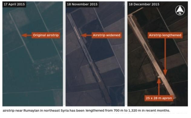
Area of an airfield expanded by the US in Syrian territory controlled by the Syrian Democratic Forces. It saw prior use as a private dirt-strip agricultural airfield until 2010; no buildings or facilities besides the airstrip itself. 2017 US construction work lengthened and widened the landing strip, presumably to accommodate larger aircraft. As of Dec. 26th, no evidence of structures or asphalt / concrete surfacing, although work reportedly continues.
As of Feb 2nd, only reports of occasional helicopters landing at site - no fixed-wing aircraft. No verification of any U.S. troop presence at the airstrip except for site visits via helicopters.
YPG and U.S. DoD deny any attempt to establish a U.S. airbase, and denies that the U.S. 'controls' the airfield. The YPG has no aircraft or use for its own airfield. Work on the airstrip is assumed to be at the direction of U.S. CENTCOM, to used by the U.S. for logistics in supporting the SDF against ISIS. U.S. Special Forces soldiers are currently operating in Syria in support of the SDF and would purportedly use the airfield for Syrian operations. U.S. DoD refuses to comment on any potential SF use.
No publicly known formal permission by Syria to the U.S. to expand or use the airstrip.
Sources: now.mmedia.me/lb/en/NewsReports/566329-us-preparing-air...
www.al-akhbar.com/node/247373
www.kurdstreet.com/?p=27144
sputniknews.com/middleeast/201610041045991523-syria-us-...
www.reuters.com/article/us-mideast-crisis-syria-usa-bas...
edition.cnn.com/2016/02/02/middleeast/syria-isis-us-air...
www.sana.sy/?p=1512518
Nearby cities:
Coordinates: 36°53'52"N 41°59'46"E
- Türk Kara Kuvvetleri saldırgan 41 km
- Türk Kara Kuvvetleri 69 km
- Turkish Land Forces offensive 70 km
- Turkish Land Forces offensive 85 km
- Turkish Land Forces Türk Kara Kuvvetleri offensive 104 km
- Syrian Democratic Forces offensive قوات سوريا الديمقراطية Quwwāt Sūriyā al-DīmuqrāṭīyaHêzên Sûriya Demokratîk 107 km
- Syrian Democratic Forces offensive قوات سوريا الديمقراطية Quwwāt Sūriyā al-DīmuqrāṭīyaHêzên Sûriya Demokratîk 171 km
- Diyarbakır Airport/Airbase 197 km
- Türk Kara Kuvvetleri offensive 197 km
- Syrian Democratic Forces offensive قوات سوريا الديمقراطية Quwwāt Sūriyā al-DīmuqrāṭīyaHêzên Sûriya Demokratîk 208 km
- Tell Abu Hajar 3.7 km
- Village of Sheikh al-Basha Bin Miteb al-Assi al-Jarba (Rmaylan al-Basha) 6 km
- Derik Area (DFNS) 7 km
- Sweidiyeh oil field 10 km
- Rimelan Silos 13 km
- Kor Tepan 14 km
- Al-Yaarubiyah subdistrict 14 km
- al-Muabbada 18 km
- Al-Jawadiyah Subdistrict 25 km
- Al-Malikiyah Subdistrict 34 km