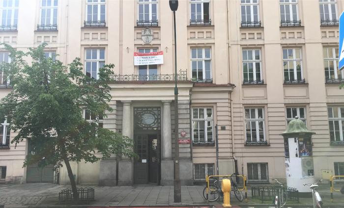
XX Liceum Ogólnokształcące im. Leopolda Staffa (Kraków)
Poland /
Malopolskie /
Krakow /
Kraków /
ul. Szlak, 5-7
World
/ Poland
/ Malopolskie
/ Krakow
World / Poland / Lesser Poland
secondary education, listed building / architectural heritage, 1911_construction
Nearby cities:
Coordinates: 50°4'12"N 19°56'1"E
- Willa Pod Stańczykiem (Collegium Sanockie) 0.4 km
- Church of the Visitation of the Blessed Virgin Mary 0.6 km
- Reformed Franciscan Monastery 0.6 km
- Plebania kościoła św. Floriana 0.7 km
- Faculty of Civil Engineering 0.7 km
- Wojewódzka Biblioteka Publiczna 0.7 km
- Krakow Train Station 1.1 km
- Cracow University of Technology - Faculty of Physics, Mathematics and Computer Science 1.9 km
- Main museum hangar 4.2 km
- The Church of St. James the Apostle in Wieclawice Stare 12 km
- Reformed Franciscan Monastery 0.6 km
- Cracow University of Technology - "Warszawska" Campus 0.6 km
- Area V of Payed Parking Zone P6 0.8 km
- Payed Parking Zone P1 (with limited entrance) 0.9 km
- District No. I, Stare Miasto 1 km
- Zone A with limited entrance 1.2 km
- Planty 1.2 km
- District No. V, Krowodrza 1.2 km
- Zone B with limited entrance 1.2 km
- Old town of Cracow 1.3 km
Reformed Franciscan Monastery
Cracow University of Technology - "Warszawska" Campus
Area V of Payed Parking Zone P6
Payed Parking Zone P1 (with limited entrance)
District No. I, Stare Miasto
Zone A with limited entrance
Planty
District No. V, Krowodrza
Zone B with limited entrance
Old town of Cracow