Belaichari Upazila HQ
Bangladesh /
Rangamati /
Kaptai /
World
/ Bangladesh
/ Rangamati
/ Kaptai
World / Bangladesh / Chittagong / Rangamati / Parbattya Chattagram
hills, township, subdistrict, fourth-level administrative division, local government
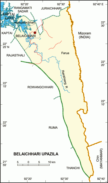
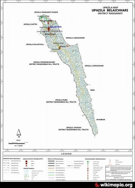
Belaichhari Upazila (Rangamati district) with an area of 745.92 sq. km is bounded by Juraichhari and Rangamati sadar upazilas on the north, Ruma and Thanchi upazilas on the south, Mizoram (India) and Myanmar on the east, Kaptai, Rajasthali and Rowangchhari upazilas on the west. Main rivers are Rainkhiang. Main lake is Rainkhiangkain and part of Kaptai lake is situated on the north-west corner.
The location of the Belaichari town is 22.5002616N 92.3389994E. Belaichhari (Town) consists of one mouza. The area of the town is 10.36 sq km. The town has a population of 1841; male 59.09%, female 40.91%. Density of population is 178 per sq km. Literacy rate among the town people is 45.9%. The town has one dakbungalow.
Belaichhari thana, now an upazila, was established in 1976. It consists of 3 union parishads, 9 mouzas and 30 villages.
Historical events: Tribal insurgencies very often used to occur in this upazila. After the war of liberation in 1971 about two thousand tribal joined the rebel Mizos. which later formed the Shanti Bahini. To resist the activities of the Shanti Bahini, the government of Bangladesh established the Farua Police Outpost. Later on the Shanti Bahini and the Parbatya Chattagram jana-samhati samiti transferred their main centre of activities to Tripura, and consequently the importance of Farua outpost was minimised to be included into Belaichhari Thana.
As of the 1991 Bangladesh census: Population 17973; male 55.39%, female 44.61%; Muslim 15.25%, Hindu 2.84%, Christian 9.26%, Buddhist 71.87% and others 0.78%.
Literacy and educational institutions: Average literacy 21%; male 29.9% and female 9.6%; educational institutions: high school 1, primary school 30.
Main occupations: Agriculture 32.43%, agricultural labourer 11.97%, wage labourer 3.37%, commerce 6.74%, service 5.49%, forestry 31.34%, fishery 2.43% and others 6.23%.
Land use: Major portion of land consists of hills and forests. In the hills Jhum cultivation is common. Forest and residential land include 277.47 sq km.
Land control: Absolute land ownership belongs to the state; but cultivable and residential land are distributed on the basis of possession.
Main crops Paddy, cotton, sesame, ginger, hilly potato and vegetables.
Health centres Upazila health complex 1.
Nearby cities:
Coordinates: 22°29'23"N 92°20'31"E
- Chandanaish Upazila 47 km
- Patiya Upazila (পটিয়া) 58 km
- Banshkhali Upazila (বাঁশখালী উপজেলা) 61 km
- Matlab Upazila (North) Area 214 km
- Lohajang Upazila 246 km
- Rupganj Upazila 246 km
- Keraniganj Upazila 256 km
- Kapashia Upazila 274 km
- Gafargaon Upazila 299 km
- Dhobaura Upazila 364 km
- Kaptai Dam & Hydro Power Plant 12 km
- Shaheed Moazzam 13 km
- Wagga Chara Tea Garden 20 km
- CHANDRAGHONA, Rangunia-Kaptai 23 km
- Kaptai Lake (কাপ্তাই লেক) 25 km
- Rangamati District 33 km
- Boalkhali Upazilla 37 km
- Chattogram District Area 57 km
- Bandarban District 80 km
- Mizoram 99 km