Macap Dam
Malaysia /
Johor /
Simpang Rengam /
World
/ Malaysia
/ Johor
/ Simpang Rengam
World / Malaysia / Johor
dam
Add category
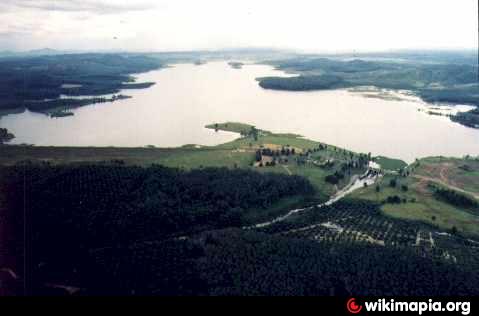
Macap dam, completed in 1982 is a part of an extensive drainage infrastructural works carried out under the Western Johore Agricultural Development Project. The dam is located approximately 0.8km behind Macap town on Sungai Macap, a tributary of Sungai Benut.
The primary purpose of Macap dam is for flood mitigation. The dam serves to store part of flood discharge of Sungai Benut, thus reducing the intensity of flood downstream. It was designed to retain a 25-years flood with a maximum downstream release of 540 cusecs, which is the capacity of downstream channel. The stored water in the reservoir is used to regulate Sungai Macap flows to Syarikat Air Johor intake located further downstream for domestic water supply. Currently, Syarikat Air Johor is abstracting about 2Mld from Sungai Macap. The hydro electric turbine provision was not utilised because it was uneconomical.
The dam comprises an earthfill main dam, an earthfill saddle dam and a service spillway structure with radial gates
Visit : www.water.gov.my/index.php?option=com_content&task=view&id=305&Itemid=835
Nearby cities:
Coordinates: 1°55'25"N 103°15'6"E
- Sembrong Dam 11 km
- Linggiu Dam 48 km
- Anak Endau Dam 81 km
- Waduk Bulan Lintang 127 km
- Tembesi Dam 135 km
- Empang Paya Cantik 219 km
- The area of protection zone the water catchment area Bukit Subang Dam 244 km
- Sultan Mahmud Dam and Power Station 348 km
- Batang Ai Dam 953 km
- Dam Sen Water Park 1053 km
- Machap Reservoir 2.6 km
- Tropical Village 6 km
- Simpang Renggam Chinese Cemetery 10 km
- Taman Rengam Jaya 13 km
- Taman Damai 13 km
- Penjara Spg. Renggam 13 km
- Betallion Ke-5 Pasukan Gerak Am (PDRM) 14 km
- Exit 247 - Simpang Renggam 17 km
- kg. pinggir 18 km
- Johor 21 km